| |
|
|
|
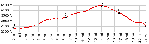
1.(2340ft,mile00.0)START-END
SOUTH-1 ALT: I5 exit south of Dunsmuir
2.(3360ft,mile08.5)profile truns from S Old Stage Rd
onto Azalea Dr
3.(4470ft,mile14.0)TOP: profile turns right to Soda
Creek Rd
4.(3840ft,39.0miles)profile turns right at this saddle
5.(2530ft,mile21.0)START-END SOUTH-2 ALT: just south
of Siskyou Ave - Deer Haven Dr, Dunsmuir
|
|