| |
|
|
|
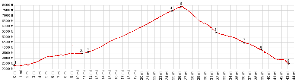
1.(2340ft,mile00.0)START-END SOUTH-1 ALT: I5 exit south of Dunsmuir
2.(3460ft,11.7mile)profile turns right from Old Stage Rd, onto W Lake St into Mt Shasta City
3.(3580ft,11.5mile)START-END SOUTH-1: Lake Street crosses Mt Shasta Blvd in Mt Shasta City
4.(7480ft,mile24.7)profile turns right onto trail through Panther Meadows
5.(7910ft,mile26.5)TOP: highest point, immediatel before the turnoff to the top of Grey Butte
6.(5450ft,mile31.7)route reaches parking lot for Skipark parking area
7.(3840ft,39.0miles)START-END SOUTH-2 profile turns right at this saddle
8.(3840ft,39.0miles)profile turns right at this saddle
9.(2530ft,mile43.2)START-END SOUTH-2 ALT: just south of Siskyou Ave - Deer Haven Dr, Dunsmuir
|
|