| |
|
|
|
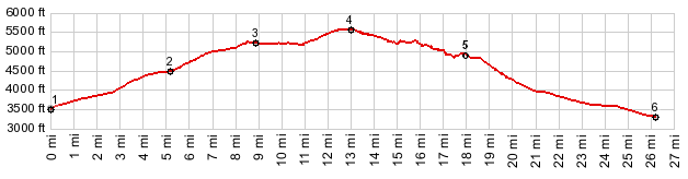
1.(3490ft,mile00.0)START-END WEST: jct I5-Ca89, just south of Mt Shasta City
2.(4470ft,mile05.1)profile turns left up Ski Park Highway on top of Snowman's Hill
3.(5240ft,mile08.9)route stays right onto FR31
4.(5620ft,mile13.0)TOP: point of highest elevation
5.(4970ft,mile17.9)START-END EAST: profile goes down "Winding Way" on right
6.(3310ft,26.2mile)START-END EAST ALT: jct Ca89 - Pilgrim Creek Rd
|
|