| |
|
|
01.(km00.0,1260m) START-END EAST: jct Road22-Road541, north of Longview
02.(km43.3,1530m) START-END EAST ALTERNATE: Forestry Trunk Road (dirt road) joins on left
03.(km80.8,2227m) TOP: Highwood Pass
04.(km97.9,1730m) START-END WEST ALTERNATE: turnoff to upper Kananaskis Lake and Smith-Dorien Spray Trial on left
05.(km125,1460m) START-END WEST: turnoff to Kanasaskis Village on left
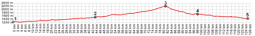
profile is half size, compared with other profiles in these pages, but same vertical exageration (9.1), rendered with gpsvisualizer.com
| |