| |
|
|
|
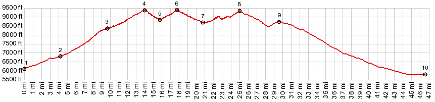
01. START-END NORTH: jct Co96 - Co87,
Wetmore
02. jct with Northcreek Rd on left
03. profile turns left onto Greenhorn Highway in
McKenzie Jct
04. 9479ft - Wixson Divide
05. 8840ft , intermediate low point at jct with road
down South Hardscrabble Creek
06. 9400ft - Bigelow Divide
07. 8720ft ,intermediate low point
08. 9360f - Greenhill Divide, just before jct with Co78
to its summit in the Wet Mtns
09. jct with Old Isabel Rd on the left
10.START-END SOUTH: jct Co165 - I25, Colorado City
|