| |
|
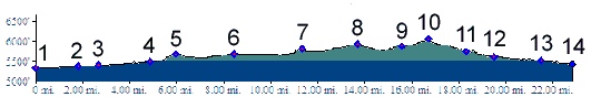
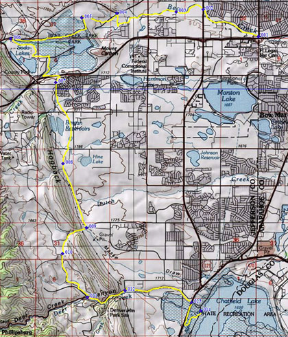
01.(5350ft,mile00) START-END NORTH: jct Bear Creek Path - Sheridan Ave
02.(5390ft,mile02) jct: Bear Creek Path - Wadsworth Ave.
03.(5400ft,mile03) jct: Bear Creek Path - Garrison Ave bike route
04.(5510ft,mile04) jct: Bear Creek Path - Morrison Rd. Route follows road into Golf Course
05.(5680ft,mile06) intermediate high point on Bear Creek Damn, north of lake
06.(5680ft,mile07) profile turns left onto C470 path
07.(5810ft,mile12) intermediate high point on south side of Bear Creek Reservoir, near intersection with Quincy Ave
08.(5950ft,mile14) C470 bike path - Bowles Ave(sh)
09.(5890ft,mile16) jct C470 bike path - Ken Caryl Ave
10.(6060ft,mile) TOP: South Valley Rd(sh), also intersection with Valley Pkwy
11.(5750ft,mile) profile turns left down Deer Creek Canyon
12.(5620ft,mile) jct with Ute Dr on left. Profile stays right
13.(5520ft,mile) START-END SOUTH: jct Deer Creek Canyon - Wadsworth Blvd. Profile turns west, shortly thereafter left into Chatfield state park
14.(5440ft,mile) START-END SOUTH ALT: Chatfield reservoir water access