|
|
|
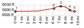
1.START-END EAST-1: 5320ft - low point
close to US50 on the east side of Canon City.
2.5640ft - profile turns right from US50 onto Skyline Dr
3.TOP: 5840ft
4.end of Skline Drive at trailhead
5.START-END EAST-2: 5360ft- profile rejoins the
EAST-1 approach in downtown Canon city at a point
between 1 and 2.
|