| |
|
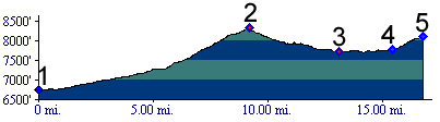
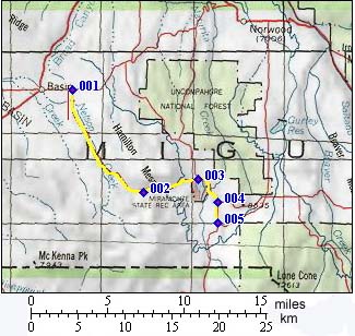
1.(6750ft,mile00) START-END WEST: Basin
School, junction of U29rd and rdU31
2.(8323ft,mile09) TOP: Sandy's Fort Pass
3.(7720ft,mile13) Miramonte Reservoir, another dirt road
heads left towards Norwood
4.(7730ft,mile16) Both forks go to 31.00rd. Profile
continues to righ, which is the shorter route to Lone
Cone SWA summit(u)
5.(8100ft,mile17) START-END EAST: junction with 31.00rd;
connects to Lone Cone SWA summit(u) profile.