| |
|
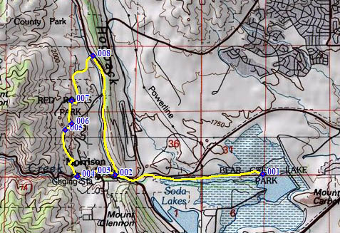
1.(5570ft,mile00) START-END EAST 1 ALT: shore of Bear Creek Reservoir on north side.
2.(5750ft,mile03) START-END EAST 1: Morrison: jct Co26 to I70 - Bear Creek Canyon Rd
3.(5820ft,mile03) Red Rocks Trail Rd on right is another lower access to Red Rocks Park
4.(5840ft,mile04) profile turns right up Titans Rd, at exit 3 to Red Rocks Park
5.(6250ft,mile04) small intermediate summit point
6.(6180ft,mile04) profile stays turns left on Trading Post Rd.
7.(6290ft,mile05) TOP: just before jct: Trading Post Rd - Red Rocks Loop Rd and dead end to upper access to amphitheater.
8.(6100ft,mile06) Red Rocks Loop Rd/ West Alameda Parkway terminates on Co93, across from road up Dinosaur Ridge.
9.(2750ft,mile07) START-END EAST - 2: Morrison: jct Co93 - Bear Creek Canyon Rd (same as point 2)