| |
|
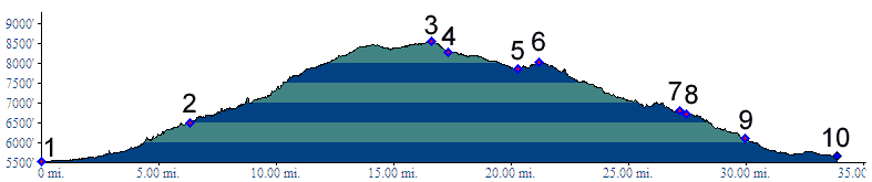
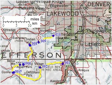
01.(5530ft,mile00) START-END
SOUTH: jct Deer Creek Canyon Road - Wadsworth
Boulevard west of Chatfield Reservoir, Lakewood
02.(6500ft,mile07) profile turns left up South Deer Creek Canyon Road. It turns into High Grade Road
03.(8540ft,mile16) TOP
04.(8290ft,mile17) profile turns right onto four lane US285 in Conifer
05.(7870ft,mile21) Turkey Creek Canyon Road diverts on right at Myers Ranch Park. Profile continues on US285
06.(8020ft,mile22) intermediate high point
07.(6830ft,mile27) Turkey Creek Canyon rejoins US285 on right.
08.(6730ft,mile28) Road to Dix Saddle aka Parmallee Gulch takes off on left
09.(6110ft,mile30) START-END NORTH: Morrison exit on US285
10.(5660ft,mile34) END NORTH ALTERNATE: Simms Street exit on US285