| |
|
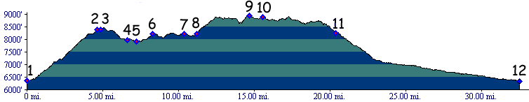
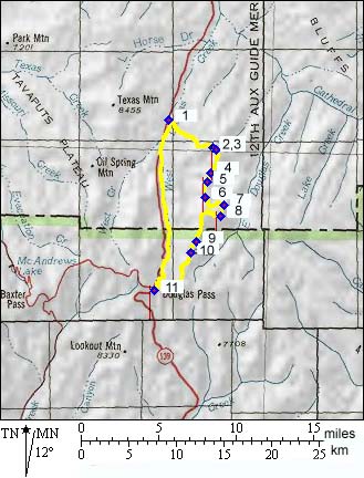
01. (mile00.0,6351ft) START-END: NORTH EAST: Rope Canyon turnoff on northern approach from Rangely to Douglas Pass
02. (mile4.50,8383ft) stay right, but either route will lead to ridge
03. (mile4.75,8381ft) Brushy Point s(u: at this four junction profile contiunes right on Ridge Rd.
04. (mile6.70,7975ft) stay on ridge first road with a somewhat abandoned appearace
05. (mile7.30,7927ft) jeep trail joins from left, stay straight
06. (mile8.40,8227ft) turn hard left, do not go right even if your intuition tells you to. The correct route goes east, then south
07. (mile10.40,8237ft) stay left
08. (mile11.20,8221ft) go left up steep climb
09. (mile14.75,8954ft) HIGH POINT
10. (mile15.50,8904ft) dead end to radio tower is on right, jeep trail is now a good dirt road
11. (mile20.40,8255ft) DOUGLAS PASS TOP, hard top road, turn right to descend back to starting point
12. (mile32.6,6351ft) START-END SOUTH EAST: Rope Canyon turnoff on Douglas Pass Road