| |
|
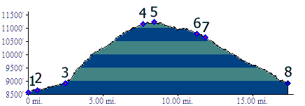
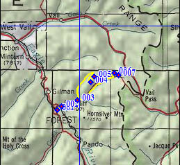
1.(8600ft,mile00) START-END WEST 1: lower access road to Redcliff below Co24 bridge
2.(8670ft, mile01) Redcliff at Shrine Pass turnoff
3.(8910ft,mile03) Profile turns left up Lime Creek Road
4.(11170ft,mile08) double track trail merges onto good dirt road. Turn left
5.(11240ft,mile09) TOP
6.(10780ft,mile12) profile stays right downhill, at this junction with FR712
7.(10650ft,mile12) junction with Shrine Pass Road. Profile turns right downhill
8.(8910ft,mile18) START-END WEST2: same point as 3