| |
|
|
|
-
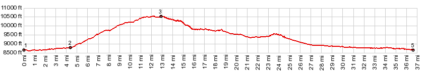
1.(8650ft,mile00)START-END NORTH: west end of Terrace Reservoir
2.(8780ft,mile04.3)profile truns left onto Silver Lakes Rd
3.(10550ft,mile12.9)TOP: Silver Lakes Rd
4.(9790ft,mile16.0)profile turn left onto FR250, coming down from Stunner Pass
5.(8660ft,mile36.7)START-END SOUTH: jct FR250 with Co17, over Cumbres Pass
|
|
-