| |
|
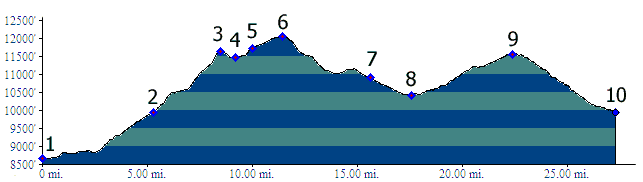
1.(8670ft,mile00) START-END NORTH 1: Lake City, bridge across Henson Creek
2.(9950ft,mile06) profile turns right onto BLM3323
3.(11650ft,mile09) START-END NORTH 1 ALT. intermediate high point before entering Rambouillet Park
4.(11480ft,mile.10) intermediate low point
5.(11720ft,mile11) profile turns left onto Colorado Trail
6.(12040ft,mile12) TOP
7.(10898ft,mile16) START-END NORTH2 ALT: profile turns left at top of Spring Creek Pass, going down north side
8.(10400ft,mile18) low point between Spring Creek Pass and Slumgullion Pass
9.(11560ft,mile23) high point on road, east of Slumgullion Pass
10.(9950ft,mile28) START-END NORTH 2: same as point 2
