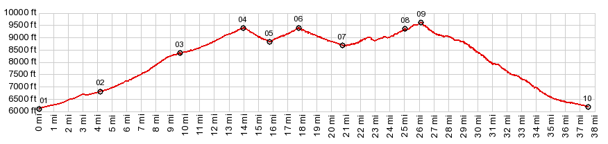
01. START-END NORTH: jct Co96 - Co87, Wetmore
02. jct with Northcreek Rd on left
03. profile turns left onto Greenhorn Highway in
McKenzie Jct
04. 9479ft - Wixson Divide
05. 8840ft , intermediate low point at jct with road
down South Hardscrabble Creek
06. 9400ft - Bigelow Divide
07. 8720ft ,intermediate low point
08. 9360f - Greenhill Divide, profile turns left, soon
after this point
09. TOP: 9600ft Co78 Wet Mountains s(u)
10. jct with Old Ham Rd. Profile stays left towards
Beulah
11. START-END SOUTH: jct Co78 - Northcreek Rd, east of
Beulah