| |
|
|
|
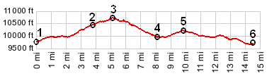
1.(3000m~9842ft,km00.0~mile00.0) START-END NORTH: jct CR99 - CR9 northern access rd to Turquoise Lake
2.(3195m~10482ft,km06.3~mile03.8) Uncle Buds Rd takes off on right
3.(3259m~10692ft,08.3km~mile05.2) TOP
4.(3053m~10016ft,km13.0~mile08.1) access road to northern end of lake is on left
5.(3117m~10226ft,km15.8~mile09.8) Hagerman Pass road takes off on right
6.(2960m~9711ft,km23.4~mile14.5) START-END SOUTH: jct CR99 - CR4 southern access rd to Turquoise Lake
|
|