| |
|
|
|
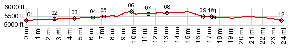
01.START-END SOUTH-EAST:jct Platte River Trail - Clear Creek Trail, at bridge over Platte River
02.Trail crosses under Sheridan Ave
03.Trail crosses under Wadsworth Ave
04.Trail crosses under Kipling Ave
05.route comes close to Morrison Rd and enters the regional park
06.TOP:5770ft
07.profile turns north on C470 Trail
08.profile turns east on Morrison Rd
09.point 5 is just a few feet away
10.profile turns south on Kipling St (not Ave)
11.route continues west on Yale Ave6
12.START-END NORTH-EAST:jct Platte River Trail - Dartmouth Ave
|