| |
| |
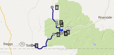
Wy70 Battle Lake Pass Rd -
FR801 Deep Creek Rd s(u)
This shoulder summit point is on
the way to Battle
Lake Pass (often also called Battle Pass) in
the Sierra Madre of Wyoming. But before reaching
the summit of the pass, the route turns down the
unpaved Deep Creek Rd, a relatively deep valley
running parallel to the range, direction north to
Rawlins. The entire profiled route is part of the
Great Divide Mountain bike touring route.
slit
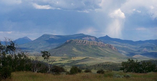
Wy70 slips across the border into Colorado for a short distance. By the time the road passes Battle Mountain and the jct with CR129 to Steamboat Springs it is back in Wyoming territory. Now Wy70 passes a distant farmhouse to the left, and then slowly climbs along a meadow with a great distant view of the Mount Meadow, Mt Diamond and the Hahn's Peak area. The last two times I have cycled this was during late evening light and the virga (that is rain not reaching the ground) found a great stage set to display its light show here. Next part: the road disappears in the forest and
crosses the Savery Stock Driveway. The small
informational tablet about this historic road next
to the road next to the road is easily missed.
Sheep herders used it to drive their stock from
the Red Dessert in north central Wyoming to the
Park Range in Colorado. Unfortunately the road was
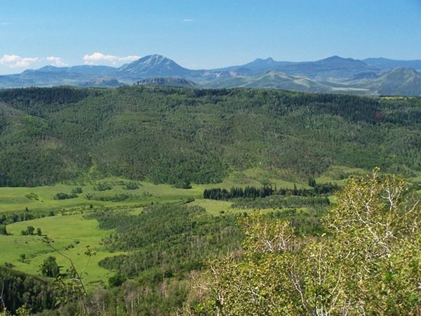
too muddy to ride during my visit. Right near the highest point of the profile,
there is very short detour to the nicest viewpoint
along the entire Battle Lake
Pass Rd. The specialty status of this point
is enhanced by the fact, that generally you have
the landscape to yourself - in my case, not a
single person around for miles.
From North. (described
downwards) The FR801 turnoff is signed, and the
profiled route takes it. After passing a short
mysterious narrow stretch through a beautiful
grove of aspen trees, that enjoys local fame for
its fall color, the road is being reworked into a
major highway, with a hard medalled surface.
During my ride in 2015 it was hard to tell exactly
what the final product will feel like on a
bicycle. During that traverse it seemed like all
of Wyoming's formerly unemployed energy workers
were busy along the entire length of the road:
convoys of gravel trucks from Rawlins, earthmovers
moving earth, water trucks attempting to the road
into a sea of mud. I would still call it a nice
ride, and a popular one too, because it is part of
the often cycled "Great Divide MTB touring route".
The road reaches a low point along Deep Creek, and
then starts climbing again on the way to the FR401
Sage Creek Rd summit.
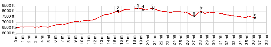
Dayride with this point as highest summit: PARTIALLY PAVED / UNPAVED ( < FR42
Mill Creek Rd s(u) | Battle Lake
Pass > ) |
|
|
advertisement |
|
|
advertisement |