| |
| |
Separation Peak s(u)
Separation Peak is a transmission
tower on a ridge outside of Rawlins. But this is a
special ridge, and a special location on that
ridge. The ridge runs along the Continental
Divide, and this peak is where the divide splits
into an Atlantic Rim and a Pacific Rim, enclosing
between them the Great Divide Basin, also called
Sweetwater Basin. Now the name makes more sense.
To the south of the peak runs, what once used to be a major east west thoroughfare in a past decade - Bridger Pass and the Overland Trail, now a scenic dirt road. To the west of the ridge runs - the road that replaced it - the Union Pacific transcontinental railroad, and also I80. Thousands of people race through Wyoming below. But up here I only saw antelopes, rodents and birds - at least in the living creature category.
Past the start of that road, at a particularly
attractive overlook over the small dessert lake
puddles along this route, a sign tries to explain
the land status in this area. Private and BLM land
alternate in a curious "almost checkerboard"
pattern. This explains the other signs, that come
later, saying "no trespassing on private land".
However the roads are public, and much of
the land is too. A gps receiver is very useful in
determining the exact land status.
Before reaching the summit of Bridger Pass,
only one good dirt road turns off to the right,
located roughly halfways up. Along this road are
many aforementioned signs. A curious set of
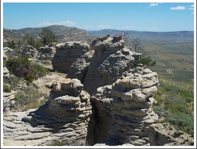
switchbacks winds past gas tanks, and up to the
crust on top of the ridge with its many cake like
layers exposed on this side - the strike slope.
It's not a big climb but it does have a short,
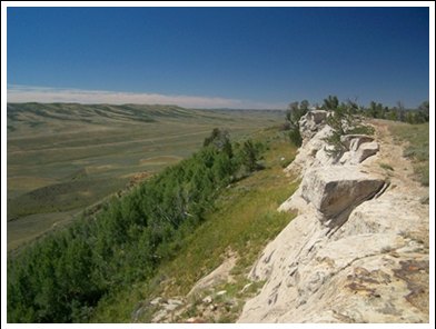
very steep section. Of particular interest is the caprock on this
ridge, because of its distinctive white color, the
strong crossbedding and the many peculiar
erosional forms it makes, on top of this sweeping
plane of sage. Some hearty trees also like to get
their roots in between these layers, and the ones
that don't quite make it, are still great
photogenic objects. Getting off the bike and
examining the edge of the cliff closer provides a
better look. Continuing on top of the plateau I
repeatedly hear motor noise from around the next
turn. But when I get there, the motor always turns
out to be operating a well site. The highest point
is reached directly across from the transmission
facility. From North. (described
downwards) Shortly after the summit the ends at a
T. On this first ride in the area I went right and
followed the most traveled road back down. But
there are other options. On my option there are
still intervening ridges between the road and the
railroad below. But the view reaches north to
Fontenelle Reservoir and the distictive dessert
ridges in the Great Basin. In my case antelopes
outnumber other vehicles by infinity. (at least
that's what I get when I divide a number by 0). The road quickly decends through a gap back to
the Bridger Pass side. Near the bottom it crosses
a gate to a "private checkerboard square", which
appears to be a private dump site, or maybe it
once was a ranch. Below that the road merges back
onto Wy71/FR401, at a completely unsigned
intersection, a short distance north of the
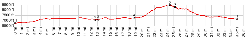
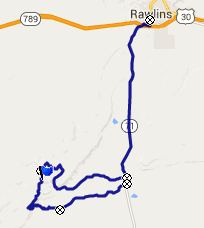
Bridger Pass turnoff. PARTIALLY PAVED / UNPAVED: ( < Hydrology Road s(u) | CR291 Seminoe - Alcova Scenic Byway northern summit s(u) > ) Separation Peak s(u) : Teton Reservoir > Wy71 north > Bridger Pass Road west > unsigned road north > Separation Peak s(u) > unsigned road east and south > Wy71 north > Rawlins with several miles of sightseeing detours > Wy71 south back to starting point on Teton Reservoir: 58.2miles with 3720ft of climbing in 5:51hrs (Garmin etrex30 m5:15.6.23) |

|
|
advertisement |
|
|
advertisement |