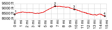
FR550 Hog Park - Red Dirt Park s(u)
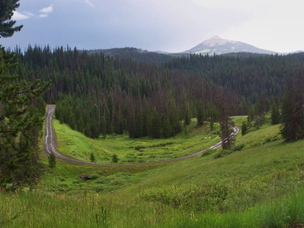
This wide dirt road links two prominent parks in the aptly
named Park Range, the range of many parks - not the
manmade, but the natural kind. The road crosses the
Continental Divide, even if it's hard to tell from the
scenery.
 |
1.(mile00.0,8450ft)
START-END NORTH: low point on FR550 in Hog Park
2.(mile06.7,9250ft)TOP:highest point on FR550
3.(mile10.0,8280ft)FR550 crosses into Colorado
4.(mile14.7,8270ft)FR550 reaches low point while
crossing Middle Fork of the Snake River
|
Approaches
From North. FR550 reaches a low point
where the water from Hog Park reservoir floods across the
road, just shallow enough so that I can ride around it. The
profile takes a hard left a short distance after the
reservoir. My destination is Steamboat Springs, as the sign
says. The same sign indicates an alternative to the right,
that seems like a whole world away: Encampment, Wyoming. This
is not just a simple directional sign, but also a testament to
the remoteness of this area. There is also a second left in
this area. But it just dead ends at the reservoir.
The road climbs in bits and pieces, safely remaining in the
forest and far away from far open views, except for the
occasional small park and small reservoir along the way. At
the top a sign announces the turnoff to the Pipeline Trailhead
for the Continental Divide Trail.
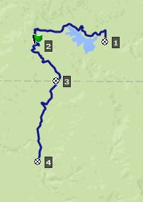
From South (described downwards).
The Continental Divide crossing is not signed along this road,
but I am assuming it runs along the top. The entrance to
Colorado on the other hand is signed, and new distances are
given for Columbine and Steamboat Springs. There are
alternatives to descend towards the north side of Columbine
Pass and Savery, Wyoming. But the profile stays on FR550
and ends back in Red Dirt Park. To continue to Columbine this
way involves another small climb after the profile.

FR550 after a short summer shower with Hahn's Peak in the
background
A ride with this point as intermediate summit is on
page: FR500 Red Dirt Park - Hay
Park
|