| |
| |
CR409 Pathfinder Rd(sh)
The wind in this part of Wyoming
can be ferocious, and going against it makes the
constant view of the horizon even more constant,
because it takes longer. This small summit lets
you get away from the wind, to a degree anyway,
and the horizon too, but only for half the loop.
Pathfinder Rd and Fremont Canyon follow a pleasant
route following an interesting portion of the
North Platte River to an improbable manmade sea in
the dessert.
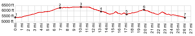
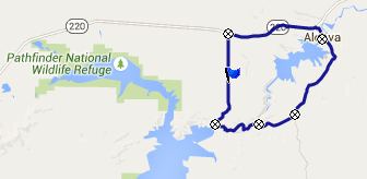
From South. (described downwards) FR409 heads north in a equally straight line, but at least it goes over some rolling hills and the view of the Pedro Mountains ahead promise a pleasant change in scenery. This change comes when the road crests a lip of rocks and descends to a glistening Pathfinder Reservoir in sweeping turns. The Pathfinder Ranch put up "No Trespassing" signs on every square inch of land that is not pubic in this confusing ownership pattern. But there is still unsigned public land in between these signs.
The name of the road changes to Fremont Canyon Road at the busy marina at point 4. Following a few turns of the North Platte River, the road gives a view of the landscape the way it was before the reservoir existed. The water has worn a few deep slots into the craggy rocks, and the road climbs around them. An intermediate low point is reached at an entrance to a hydroelectric damn, where the road crosses the Platte River. Now the road climbs up into prairie land and the
more common Wyoming landscape. At an intermediate
summit, Alcova Reservoir appears below, water
backed up against a whole series of colorful
hogback ridges extending endlessly into eastern
hogback ridglets. Alcova is the lowest part of the
loop, and the bike rolls easily in that direction.
Wy210 descends a little further east, along with
the North Platte River. That last part is not
shown in the profile. Dayride with this point as highest summit: COMPLETELY PAVED: (< CR291
Seminoe - Alcova Scenic Byway northern summit
s(u) | CR505
Casper Mtn Rd - Circle Dr s(u) > ) |
|
|
advertisement |
|
|
advertisement |