| |
| |
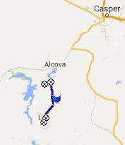
CR291 Seminoe - Alcova
Scenic Byway northern summit s(u)
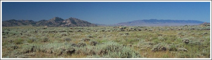
This road goes over a high plains
roller coaster along a series of form rich
sandstone mountains, the Pedro Mountains, just
east of the Atlantic Rim part of the Continental
Divide. (The sandstone erodes in the same way as
the Dakota Sandstone in Colorado, but I don't know
if this is actually the same formation) Trees are
a rare commodity here, but they can be spotted
from a distance. The road is a pleasant, peaceful
contrast to many other Wyoming raceways, across
which people hurry in record time to see the next
Old Faithful Geyser eruption.
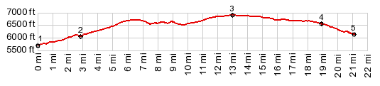
Climbing in rolls and descends the "paved" (with a large percentage of holes) road climbs a little higher with every roller, and every roller makes the Pedro Mountains to the north and the Granite Mountains behind them appear, as if set on a pedestal of a high plain. The pavement lasts to about maybe a mile of what turns out to be the real top, after examining the profile afterwards. 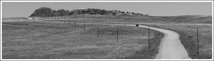 From South. (described
downwards) Several turnoffs are signed as
going to ranches and there are probably mountain
biking between there and the Pathfinder Reservoir,
although it may be quite sandy. The profile
follows the main road, which descends past Dome
Rock. This is an "stand alone outcrop" that stand
like a monument. The road now becomes a little
sandier and contains more washboard. What looks like a series of rock chimneys to the west, shimmering in the heat, turns out to be the eroded shoreline of Pathfinder Reservoir. The turnoff to there gets sandy quickly. But before reaching the sand, there is a small oasis like group of trees, giving shade for free. The profile reaches a low point where the main road ( not the Pathfinder Reservoir turnoff) crosses yet another creek named Sage at a farm. Seeing a small rivulet of water at the very bottom of such a wide expansive valley is always an amazing sight. Dayride with this point as highest summit PARTIALLY PAVED / UNPAVED ( <
Separation Peak s(u) | CR409
Pathfinder Rd s(u) > )
|
|
|
advertisement |
|
|
advertisement |