| |
| |
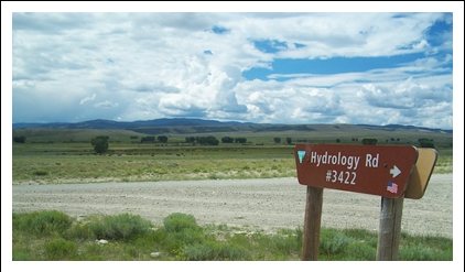
BLM3422 Hydrology Road s(u) 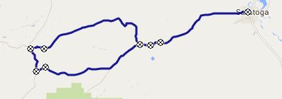 Middlebury
Hill is a windswept plateau top, open in three
directions and a sheltering grove of aspen in
the remaining direction, where it counts the
most, and that is the west, because that's the
direction from which the wind blows in Wyoming
- practically always and with great force. The
name "Middlebury Hill" is marked on BLM maps
and refers to the northern summit on the
Wy71/FR401 between Casper and the Battle
Lake Pass road. Middlebury
Hill is a windswept plateau top, open in three
directions and a sheltering grove of aspen in
the remaining direction, where it counts the
most, and that is the west, because that's the
direction from which the wind blows in Wyoming
- practically always and with great force. The
name "Middlebury Hill" is marked on BLM maps
and refers to the northern summit on the
Wy71/FR401 between Casper and the Battle
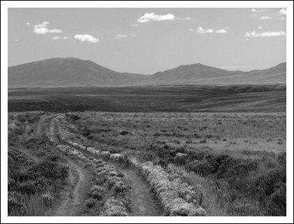
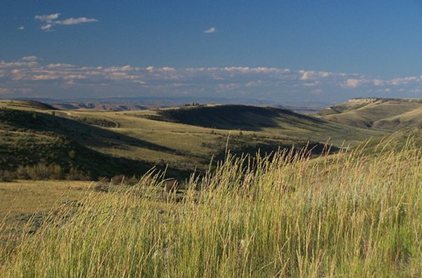
Lake Pass road.Several unpaved roads meet on top of this curiously stark Continental Divide crossing. They all reach about the same maximum elevation. But this BLM track is the highest by a few feet. A rough, not ridable track on the opposite side of FR401 goes a little higher.
Approaches The name Saratoga brings up images of refined estates and mineral baths, and they do have the baths here. Other things seem quite different. For example leaving the town along Little Jack Road, you pass a old Hoyt Axton touring bus, and then in a trailer backyard, a brick hanging from a chain. The sign below it reads "Wyoming wind gauge". Later during the ride I had to think back to this. This can be a torturous climb with the wind
blowing gale force wind in your face, and a
short very steep uniform ramp in a stark,
featureless inclined plane of sage. And it is in
the field of view for hours before you get
there. The same goes for any motor vehicles. A
plume of dust precedes its arrival by several
songs on the mp3 player. But then - to
compensate - the clouds back over Saratoga make
for a great light show with the Laramie
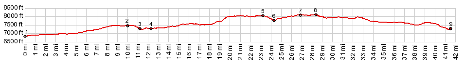
mountains behind them After the top of the plateau is reached (in my
case in the pouring rain which was now
accompanying the wind), the road descends 290ft
to the junction with Co71. Turning left this is
a summit point. But the profile turns right
(north), where the route finally reaches the
crest of Middlebury Hill. Looking closely you
can find a CD trail marker next to the road. But
they are very small. On each side of the highest
point a short access road goes up BLM3422. The
highest point is where they meet, and from there
there you also get a great view north over the
sharp edges of the plateau. From South-East. (described
downwards). This little used BLM track has a
good surface at this point. It follows the
divide for about a mile and a half, and has
sweeping panoramic views, that just cry out to
be cropped into an extreme wide format. After
the divide turns right, the road makes a
sweeping left turn instead and enters a sage
study area. A reservoir becomes visible, roughly
the size of a puddle when compared to this
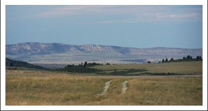
sweeping landscape. The road makes its way down to the reservoir.
There the surface of the road becomes a little
more grassy. Taking the scenic route around the
reservoir, the route eventually climbs out of
this area through a narrow ravine containing a
rare grove of trees. Once on top again, fast
dirt roads lead mostly downhill to the junction
with Jack Creek Road, with more sweeping views
onto the Sierra Madre, the foreground a speckled
mix of widely spread cows and the occasional dot
like bush. The junction point is still about 12
miles from Saratoga
MOSTLY UNPAVED ROADS ( < BLM3328
Miller Hill Rd s(u) | Separation
Peak s(u) > ) |
|
|
advertisement |
|
|
advertisement |