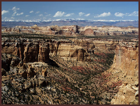
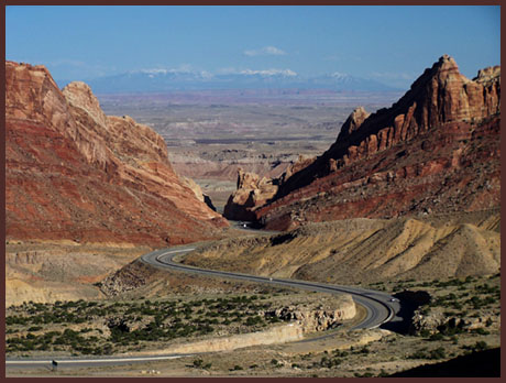
I70 San Rafael Swell summit(u)

An extraordinary 50km by 80km area of canyons in south eastern Utah has so far managed to escape the destiny of being designated a national monument or park, an area known as the San Rafael Swell. Rich with mountain biking opportunities, the swell has one paved road, and one paved road only, I70 between Green River and Fremont Junction. Riding on the spacious shoulder of I70 is not exactly a ride through the woods to Grandma's house. But for those not totally put off by riding on the shoulder of an Interstate, it's a ride through the kind of scenery that may make you want to get a Geology degree. At least that's the effect it once had on me a long time ago.


And as always, there are benefits of cycling over driving. Instead of wondering "what was that ? A canyon of some sort ?", there is time to stop and gaze into it. Instead of being mystified by the curious vertical rock markings in Spotted Wolf Canyon, there's time to observe that this is a rock cut and the markings are an engineering feature instead of geology. Instead of experiencing a bump in the road where I70 crosses Devil's Canyon, the opportunity exists for a picnic lunch next to a scenic bridge in earshot of comfortable but still discernible sounds of the modern highway.


click on profile for more detail
1.(4280ft,mile00) START-END EAST: junction I70 and Ut24 to Hanksville
2.(5360ft,mile07) Spotted Wolf/ Black Dragon Canyon overlook
3.(6640ft,mile18) Interchange provides access to Mexican Mountain and Sinbad Valley
4.(7270ft,mile27) TOP: overlook area with elevation sign
5.(6850ft,mile30) bridge over Eagle Canyon
6.(7220ft,mile32) overlooks at Justensen Flat and exit to Moore Road
7.(5620ft,mile41) START-END WEST: ranch exit along South Salt Wash
8.(5550ft.mile42) START-END WEST ALTERNATE: I70 crossing of South Salt Wash
 

Approaches

From East. This is the dramatic side of the monocline as well as the largest climb. It begins soon after the junction of Ut24 and I70. After crossing the major river of the swell, the San Rafael, I70 begins its massive breach of Navajo Sandstone through Spotted Wolf Canyon. The road soon emerges on older rocks. View points on both sides of the road are not connected and lead to different vistas, a vantage point onto Spotted Wolf Canyon (second picture) for westbound riders, an overview of Black Dragon Canyon (see picture page) and the the reef extending northwards for eastbound travelers. As the monocline levels out, the journey continues over what appears like a plane, albeit a somewhat tilted plane. This plateau like section of the monocline is called Sinbad Valley, and level cliffs of Sinbad limestone, appearing like distant lips, point the way to the summit, which is nothing more than a crease in the blanket of the landscape. This adds to the surprise of the stunning vista at the top, extending northwards across the swell and Castle Valley (first picture). The exprience is shared with truck drivers, and befuddled cross country motorists, who thought "there wasn't anything between California and some eastern state", and are now bothered by the fact that they left their camera at home and can't even find their picture phone to take a snap shot for the folks back in New York or California. The top has an elevation sign without the word summit. Furthermore I have not seen a map that designates this point as summit. Therefore the designation is followed by (u).

From West. The profile begins just west of Ranch Exit 108. There is more San Rafael Swell scenery to the west. But this is a convenient low point to start the profile. While the road on this side also cuts across geologic formations at an angle, progressively climbing through older and older formations, these rocks are much softer, and the climb appears to be nothing more than an inclined plain. It is mostly through the improving vista onto the Wasatch Plateau and to the west and occasionally induced hard breathing, that the climb makes itself felt. Personally I find the starkness of this scenery very appealing, even if it does not seem to do much for the average motorist. Road signs warn drivers to pull over at the next exit if experiencing drowsiness. If the vista over Eagle Canyon at that point, doesn't shake you awake, there is little hope left. Immediately after another exit presents the only view to the southern part of this uplift. The first high point is separated from the true summit by Eagle Canyon and a bridge over it, which motorists never have a chance to notice, but makes a nice picnick spot on a dayride.


Tours

Dayrides An out and back ride from a the junction of I70 and Ut24 over the summit to Ranch Exit 108, where Willow Springs Wash crosses I70, measured 88 miles with 6600ft of climbing in 7.3 hours. (M2:6.04.16) This also includes less than 5 miles and 500 feet of climbing, exploring short sidetrips next to the highway.


History

Early travelers, such as caravans on the Old Spanish trail or Gunnision's transcontinental railroad survey made a detour around the reef, to the north of the path of today's I70.

Modern Highways. The decision to construct I70 across the reef was reached in 1957. But ten years went by before construction began. Finally in 1970 the 70 mile stretch between Green River and Fremont Junction opened as a two lane road. Two more lanes were added in the 1980s.


Copyright (C) 2003-2008 by Michael Fiebach - All Rights Reserved


eXTReMe Tracker