| |
| |
Clay Hills Pass
When you ride to Glen Canyon and
the Colorado River, it is downhill all the way,
right ? How else would all that water get there
before it evaporates ? Almost - between Natural
Bridges National Monument and Father's Crossing
there is an actual named pass. But the top of the
pass is still more than 500 feet lower than the
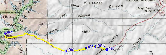
eastern end of Ut276. That point is shown on the
right side of the map below, not outlined in
yellow. Clay Hills Pass is the opposite from a
high alpine climb. But it brings an interesting
variation to this dessert ride, both in the
scenery and in the workout.
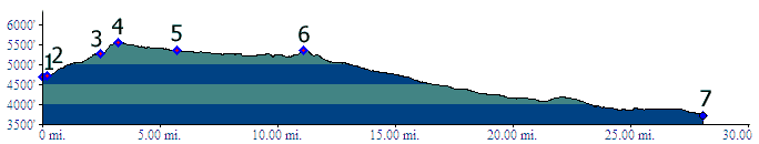
 Approaches From East. The profile begins after a
long, slight downhill on Ut276 from its junction
with Ut95. The road curves slightly to the right
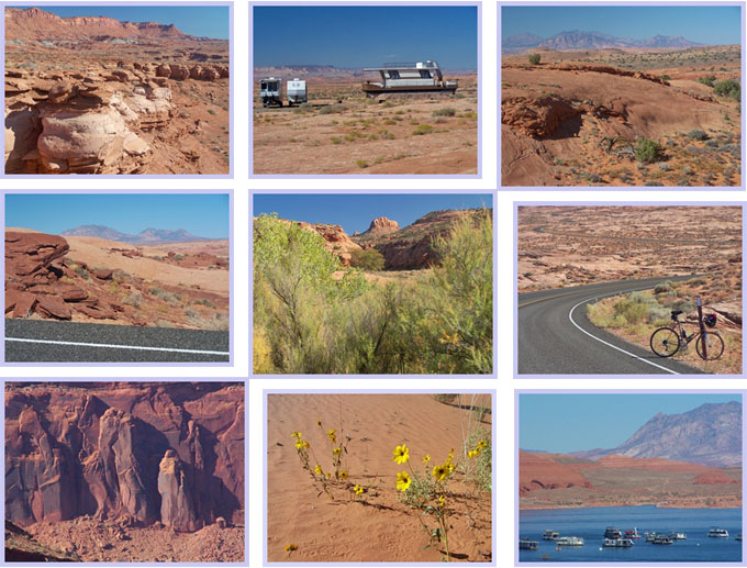
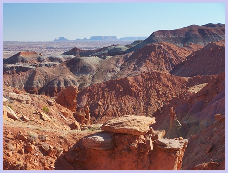
and heads up into red cliffs. To the right in the
distance you can make out the buttes of Monument
Valley, without having to endure the traffic and
road conditions in the Navajo Reservation.
Instead, here there is peace without cars and good
pavement. With a little altitude gain the road
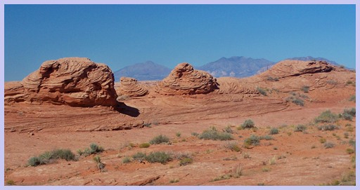
reaches the "Moenkopi munchkins" sitting on the
"Chinle elephant feet". Early evening light makes
them shine especially gloriously. Next comes a
modestly small monument, sitting on a monumentally
large parking area, extolling the virtues of
proselytizing mormon missionaries, who came this
way and did their thing in the Hole in the Rocks
area. The sign calls this divide "Clay Hills
Pass". Most maps seem to label it Clay Hills
Divide. The road keeps on climbing past the
divide, quite steeply in the end, and reaches a
high point that also marks a temporary change in
scenery.
From West. (described downwards) A more
gradual downhill leads through a small canyon,
filled with small Cottonwood trees and lots of
Tamarisk, carved by Castle Creek. All of sudden
you think you've seen something imaginary, maybe a
unreal reflection in the heat of the day (even if
it's already late October). Wasn't that a lake of
green water ? Well, lake is an exaggeration, a
pond perhaps, definitely bigger than a puddle, and
in this dessert context you might as well call it
a lake. And it was definitely green. The map
verifies the existence of "Green Water Spring".
This may explain why the handful of forlorn cows,
I encountered along the way, were still alive,
although they did look very parched.
The road keeps on dropping past the psychedelic
spring. When it reaches a second, minor high
point, it is back in the dessert. The Henry
Mountains to the north are now the only show in
town. The foreground is played by the crossbedding
of the imperturbable Navajo formation. There are
signs that the unreal seeming, manmade sea is
near, when stored houseboats start appearing on
the bare rocks. A sign reads "airport". But to me
it looked like a storage area for boats. Many are
stored in individual tents, giving the whole scene
the appearance of a deserted refugee camp. The
road keeps on dropping ever so slightly and you
can see the final destination, clear as a pencil
drawing, as you roll nearer ever so slowly, the
blue sea of Glen Canyon contained by white rock
walls. To roll the last mile down to the water,
one must invest in a 7 dollar entrance fee for a
bicycle, collected either at an entrance station
or a self service station. It does seem a little
high, compared with 10 dollars for a motor vehicle
with unlimited occupants (to put it mildly). To
the left the small, geometrically spaced trees of
the campground give the appearance of a very small
Spanish fruit orchard. To the right a spacious gas
station with attached, extremely small store sells
canned goods and returns the visitor to reality.
The attendant was also very happy to help with
some electrical tape to fix a broken electronic
part on my bike in a jiffy. To get to the ferry
requires a couple more miles of riding. By the
way, if the ferry is not operating, there is
usually a road sign indicating this back at the
junction of Ut95 and Ut276, west of Natural
Bridges National Monument. Dayride with this point as highest summit: COMPLETELY PAVED: Clay Hills Pass x 2 : out and back: jct
Ut276-Ut95 west of Natural Bridges NM <>
Ut276 <> Clay Hills Pass <> Hall's
Crossing Marina: 95.0miles with 4380ft of climbing
in 6:31hours (Vetta 100A r2:11.10.21). back to cycling Utah's summits and passes |
|
|
advertisement |
|
|
advertisement |