| |
| |
CR2261 Jacob's Chair s(u) There are several loop
possibilities connecting Co95 on the north side of
Lake Powell with the Wooden Shoe dirt road to the
north of Co95. This option uses a scenically
stunning double track trail to climb up to it, and
then a fast dirt road to cruise back down to the
valley.
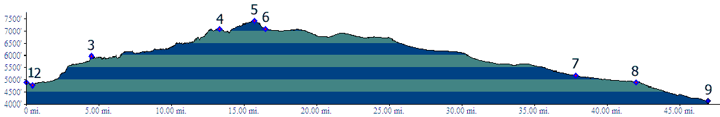
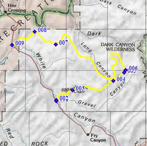
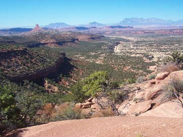
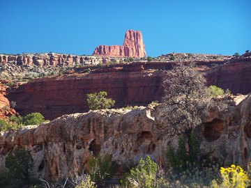
From West. The turnoff onto CR2261 from Ut95 is not easy to see. I had already missed the county road turnoff to the east, labeled "Soldier Crossing" on topo maps. (That is another possible way up) So I thought I would try out the road starting at "Gravel Crossing". Getting to the other side of White Canyon turns out to be a surprisingly easy affair, after catching glimpses of its sheer sandstone cliffs from Ut95. This is after all the same canyon that shows off all the bridges in Natural Bridges NM. The first destination for today is plainly
visible dead ahead. From this angle it is shaped
like a large, full sized boot, sitting on top of
red cliffs. But this area already has many
footwear inspired rock names. The Wooden Shoe Road
and the buttes lining it already allude to a great
variety of footwear. Instead the landform
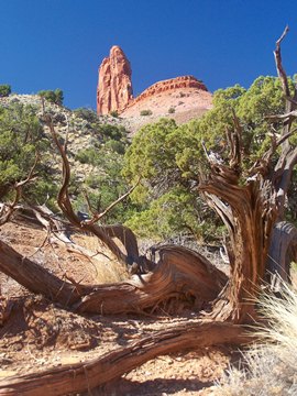
ahead is known as Jacob's Chair - so a
furniture it is. As the ride progresses a
different viewing angle will make it appear more
like a needle like monument. Then during the
return ride, Jacob's Chair will show off its broad
side, so that it almost becomes unrecognizable
from its former self during the first part of the
ride.
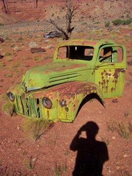
The obvious red cliffs ahead are negotiaged with a steep shelf road, too steep and rocky to ride. Before this climb there is a manditory stop for dead car afficionados. Three or four antiques have been battered, shot, killed and dragged into oblivion, so that they now make picturesque rotting mechanical caracases in the dessert. Past Jacob's chair the road becomes a double track trail, that is largely ridable again. It stays near the top of an unnamed ridge between Long Canyon and Gravel Canyon. Most if not all turnoffs have been marked as being off limits to vehicles, since this is a well known ATV route (even though I did not see any during my traversal). This has the side benefit that you can't get off on the wrong turn to a dead end. At this point of the ride it really feels like any signs of life are quite far away. Immediately afterwards a good, straight road in the white rimmed Long Canyon below shows up out of nowhere. It is so close that one might be tempted to look for a portage down to it. This is not a good idea. The route will pass along this road and the view from the bottom clearly shows off the cliffs that are not visible from the top. Some maps however show a trail heading north west along the ridge, west of Long's Canyon, a potential shorter but rougher way to get back to Ut95. This route described here just follows the main
trail. It presents dumbfoundingly stunning views,
that are like a sample platter of Utah landforms,
a needle like monument combined with a high fault
block range, a smattering of rock fins served with
a variety of deep red cliffs under spicy white
rounded Navajo rock slabs. The trail portion is
close to over when it reaches the summit. It takes
by far the most amount of time on this loop, but
also has the greatest views.
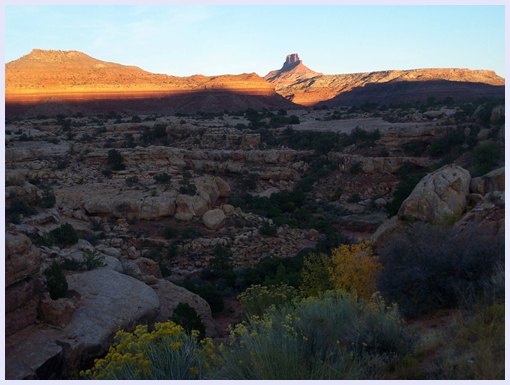
From East. (described downwards) A short, rough descend, that is just big enough so that this loop falls into the summits category, instead of the shoulder summits category, delivers the bicyclist onto CR256. There is no road sign at this junction, just a "stay on the trail" sign. CR256 is labeled as the "Wooden Shoe Road" on some maps, due to imaginative dutch inspired interpretations of the shapes of the buttes, lining the road further up. This route turns down canyon, to the left, going along the same ridge backwards. It is amazing how different the world can look from 300ft lower. Not that it's not nice down here, but it sure was spectacular up there. But then again - cruisng downhill on a fast dirt road, crossing a small washout now and then has its niceties too. Many maps give the indication that the road passes over or through something named Indian Head Pass. This pass is however located west of the road, and no road or trail crosses it, according to topo maps. The objective of the ride now has become zooming through a land of standing rocks on a slight but steady downhill. Against the evening sun, some of these rocks seem like cutouts with additional holes cut into them. Taking a left at point 7 (not a right, as the profile does) is the shortest way back. But only if you also make the next subsequent left around the north edge of Fortknocker Canyon. Without a detailed map this is highly counterintuitive, as it seems to head back into the hills, the same direction you came from. But even in this case all is not lost, and the ride statistic below includes making about all the wrong turns possible. Instead the profile opts to stay on CR256 and
take the next left onto CR2081. This is a large
triangulated junction. CR256 stays south of
Brown's Rim. All of these intersections are signed
only with CR numbers, no indication of destination
whatsoever. But staying right will also get you to
Ut95. The ride just keeps getting longer.
Hopefully there is enough light left in the day.
CR2081 curves around, doing all it can to keep the
rider, who is here for the first time, insecure
about where he is heading. The time necessary to
cross a long sandy wash heightens the
anticipation. But eventually CR2081 delivers the
cyclist to Ut95. The road, that apparently keeps
going on the other side ot Ut95, continues to Lake
Powell on the north side of White Canyon. Dayride with this point as the highest summit: PARTIALLY UNPAVED / PAVED CR2261 Jacob's Chair s(u): jct Ut95 -
CR2261 > up CR2261 > Jacob's Chair >
CR2261 Jacob's Chair s(u) > down CR256 >
left at point 7 <> out and back to end of
CR2651 >> down CR256 > south west on
CR2081 > north east on Ut95 > back to
starting point: 68.3miles with 4940ft of climbing
in 6:44hours (VDO MC1.0 m3:11.10.23). |
 Approaches
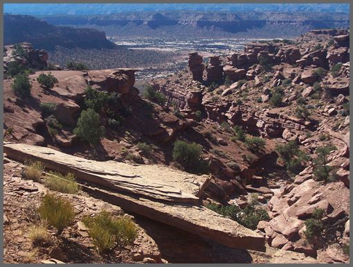
|
|
advertisement |
|
|
advertisement |