| |
| |
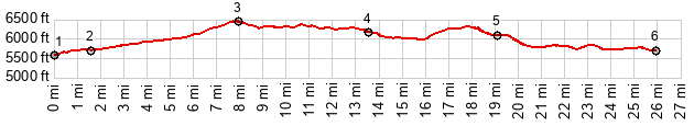
This is a gentle climb through
pleasant mesa scenery, between the biggest
concentration of gas wells that I have ever
seen. The profile includes a lower section
that is not on US64, but a curvy pleasant
paved side road to Navajo Reservoir. This is
actually the best part of the ride.
From North.
(described downwards) The descent comes with
some ups and downs and long traverses along flat
mesas. Navajo City is mostly a name on the map,
and also the location where the profile turns
onto the best part of the ride, curvy NM539
following the whims of the landscape. The
profile continues through a sandy crossing where
an intermittent stream feeds the San Juan River
to the north. Past that intermediate low point,
the NM539 still has a small high point to go
over to reach Navajo Reservoir. The climb is
greater than 300ft. But there is no way to make
it 500, and so I am not counting this as a
separate summit, but include it in this profile
and pictures on this page. Another great part of
this ride is the section, traversing slightly
above the San Juan River, as it escapes from the
dam and winds down valley between stately trees
and armies of fishermen. 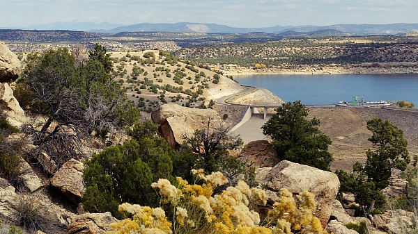 Dayride with this point as highest summit PARTIALLY PAVED / UNPAVED ( < Hesperus Pass | CR520 Delgatito Mesa s(u) > ) US64 Blanco - Navajo City , jct NM575 - Navajo Dam Rd s(u) x2 : 5 mile bridge > CR4450 north > US64 west > US64 Blanco - Navajo City s(u) > NM539 north > Navajo Dam > Navajo Dam Rd west with short out and backs on spur roads > jct NM575 - Navajo Dam Rd s(u) > NM575 towards Aztec City << turnaround point 2 miles before town center, ~400ft below summit > jct NM575 - Navajo Dam Rd s(u) > down NM575 > Blanco > CR4450 south > back to starting point at 5 mile bridge: 62.5miles with 4190ft of climbing in 5:56hrs (garmin etrex32x m6:24.10.13) Notes: comfortable morning but the afternoon is still too hot, and that on October 10th. The only unpaved section is the approach to the loop and the lower part of NM575 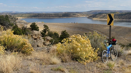 |
|
|
advertisement |
|
|
advertisement |