| |
| advertisement |
| -------- |
| advertisement |
|
Ortiz Peak
summit(u)
 This route is one way to get
from Cabresto Canyon over the divide into
Valle Vidal. It involves crossing Ortiz Peak
on the divide. For me the route offers equal
portions of confusion about the topography
and excitement about the scenery, while
crossing into one of northern New
Mexico's most interesting valleys. Back in
Spanish colonial times the horseman could
enter Valle Vidal from the the same
direction by way of the old Costilla Pass.
Today's mountain biker has to cross a higher
ridge to stay away from private property.
The route described here route consists of a
combination of dirt roads, abandoned lumber
paths and fence line trails, that are not
shown on any maps, unless they are handdrawn
by a local forest ranger. It's a good idea
to take along an extra supply of time and
flexibility for a dayride across this
summit. This route is one way to get
from Cabresto Canyon over the divide into
Valle Vidal. It involves crossing Ortiz Peak
on the divide. For me the route offers equal
portions of confusion about the topography
and excitement about the scenery, while
crossing into one of northern New
Mexico's most interesting valleys. Back in
Spanish colonial times the horseman could
enter Valle Vidal from the the same
direction by way of the old Costilla Pass.
Today's mountain biker has to cross a higher
ridge to stay away from private property.
The route described here route consists of a
combination of dirt roads, abandoned lumber
paths and fence line trails, that are not
shown on any maps, unless they are handdrawn
by a local forest ranger. It's a good idea
to take along an extra supply of time and
flexibility for a dayride across this
summit.
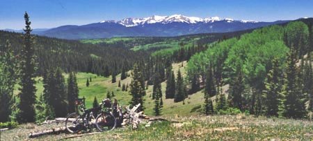
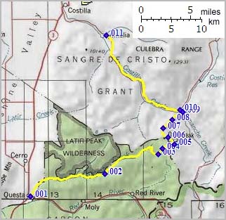
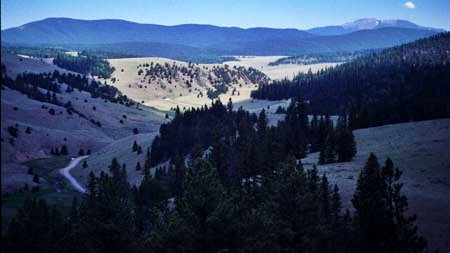
Approaches From North. To start at the bottom,
topographically speaking, one has to start in
Questa (7500ft). The route follows a
gravel road to Lagunita
Saddle. The first right after the saddle
goes to Trail Canyon ( or similar name ). The
route to Valle Vidal continues straight. A
short distance later, at the next junction,
stay left on the road that winds uphill
through a meadow into a higher forest. There
another smaller road takes off to the left.
Stay right. Cross a cow grate and take the
next right onto a forest road closed to motor
vehicles. Meanwhile the path surface
conditions have improved considerably since
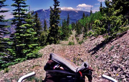
Lagunita Saddle. The closed double track leads
past a prime viewing area of Wheeler Peak (2nd
picture), through an old tree harvesting area
and curves back towards the west. This is
where it becomes tricky. At a junction a path
towards the right appears to dead end. At this
point the route crosses the Valle Vidal
boundary. A straight fence line, from which
the wire has been removed runs along the
ridge. An old fence line trail heads in a
westerly direction just inside the old Valle
Vidal boundary. This trail eventually tops at
a forested summit with a microwave facility at
11209ft.
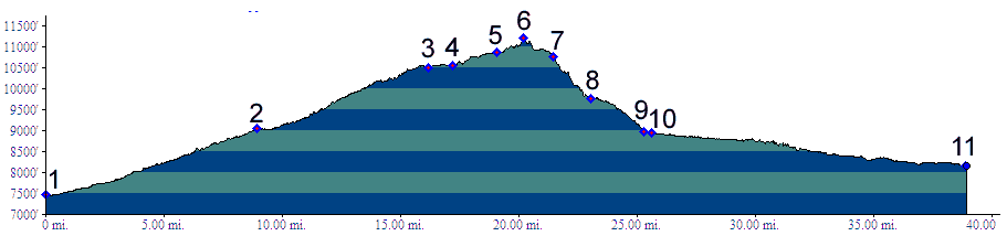
Tours Dayrides. A loop ride from Questa, climbing Lagunita Saddle via Cabresto Canyon, continuing over the divide as described, returning to the starting point by paved road through Amalia and Costilla measured 69 miles, 5310 feet of climbing in 7.1 hours using a Cateye 100A cycle computer.
 back
to New Mexico's Summits and Passes by
Bicycle |