| |
| |
AboPass
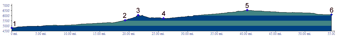
The expression "going through Abo
Pass" is a better description than "going over Abo
Pass". It's really a gap rather than a pass. But
only the railroad goes through the gap, while the
modern road climbs a shallow shoulder above the
gap to the south. The situation is made more
confusing by the fact that going down the eastern
approach of the road from the "summit" is only a
300 ft drop before the road starts climbing again.
In an effort to locate a true summit on the road
the profile continues east onto a slanted high
plain to a high point in the town of Mountain Air.
Even then the western approach descends only 450
feet. Abo Pass is not labeled on topographic maps.
But the name appears on many Gazetteer and highway
maps.
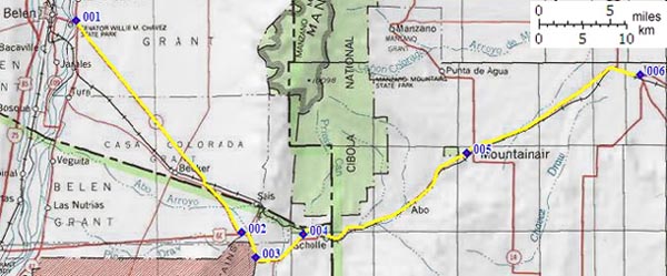
Approaches From East. Two arrow straight roads
climb along a shallow alluvial plains from the Rio
Grande to converge shortly before the real climb
to the top. The profile shows the route from Belen
which has all services. The road is designated as
bicycle route and has a good shoulder. The town at
the end of the other road, Bernardo, has a gas
station at the most. Another straight line
converges at the junction of the two roads, and
that is the ragged fault line profile of the
Manzano Mountains. Shortly before the junction the
railroad crosses to the north side. The tracks
enter a scenic gap, named Abo Canyon. The BNSF
railroad is currently engaged in an effort to plan
a second track through the rocky canyon. From the
junction it's a short but definitely noticeable
climb to the intermediate top. After a short drop
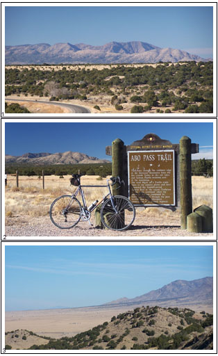
the road crosses the rails again at a historical
marker commemorating the Abo Pass Trail. The road
begins to climb again very gradually between
ravines. The old missionary and pueblo ruins of
Abo are 3/4 miles off the main road. When reaching
the highest point just short of the town of
Mountain Air and turning back it becomes clear
from the expansive view of the Manazano Range the
different character of the land on this side of
the mountains becomes clear. From the east the
Manzanos gently rise to a forested dip slope. The
entire route has a wide shoulder, although its
condition deteriorates as you approach the town of
Mountain View (Nov.07).
From West. It's hard to call this an
approach. But if Abo Pass carries the destination
pass, (even though it is really a gap), this has
to be called an approach. Even the slope sensitve
railroad does not need an elaborate constructions
to make the simple 400 ft climb from Willard. The
ride is reminiscent of a ride on the expansive mid
western plains, in that the destination high point
can be seen from anywhere in a 20 mile radius. The
point of highest elevation is actually the water
tower in the town of Mountain Air. It seems to
never come any closer until you finally reach it.
The shoulder on this side is rumble stripped, and
the ridable part is narrower than on the other
side, but still sufficient to stay out of traffic
for the most part.
Dayrides. An out and back ride between Mountain Air and
Belen over the pass twice measured 67 miles with
2300ft of climbing in 4:3 hours. The figures do
not include 15 miles between the road junction
described in the eastern approach to Belen in the
west to east direction, because I accepted a car
transport due to mechanical problems (7/11/20). History Native People. The Salinas Valley on the east side of the pass had been inhabited by natives for centuries before the Spanish brought back word of it. These pit house dwellers were assimilated by the Anasazi beginning in the 1100s, when they started building more in the style of multi story adobe apartment buidlings. One of these villages, Abo, is 3/4 mile off the pass road. The others Gran Quivira, Quarai and a few undeveloped sites located on private land, are even closer to the salt deposits in the Salinas Valley. By the 17th century the Salinas valley was inhabited by perhaps 10000 or more pueblo dwellers, who crossed the pass area, acting as traders and producers for the Rio Grande villages and the nomadic plains indians.
58 years before a brief, initial encounter
between Spaniards and the pueblo Indians of nearby
Gran Quivira Indians caused the conquistadors to
go on a Golden Goose chase all the way to Kansas..
Now the Spaniards returned for a second time. The
main attractions this time were salt in the
Salinas Valley and agriculture, but these too, did
never really turn out to be profitable. Still,
wagon loads of salt and agricultural goods
produced in the pueblos, crossed the pass to the
Camino Real along the Rio Grande, and returned
with missionary goods to the pueblos. In the end
the reason for the Spnaish to to remain was
because the pope said so. Franciscands introduced
wheat bread, fruit trees as well as exploitation
through forced tributes. Another new item introduced by the Spaniards were
"new diseases", at least new to the Indians. The
second, "new and improved" church had been in
service only for a couple of decades, when the
final chapter began. A drought and souring
relations with the apaches to the east, stopped
catholic hymns reverberating in the new church.
During the 1670s Salinas valley pueblo dwellers
moved across the pass and were absorbed by other
villages along the Rio Grande. The village of Abo
was one of the last hold outs, already absorbing
inhabitants of the lower Salinas Valley before
they had to move again, this time all the way down
the pass to the Rio Grande pueblos. This was 10
years before pueblos on the upper Rio Grande
revolted against Spanish rule on a large scale and
managed to expell them for a number of years. Railroads. The pass was crossed by the
Sante Fe railroad in 1908, when they completed the
Belen cutoff. Today the railroad is attempting to
convert the extremely busy single track line into
double tracks. back to
New Mexico's summits and passes by bicycle |
 Tours
Tours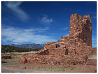 Spanish Colonialism. Then
came the Spaniards, and in the words of the
National Monument ranger I talked to - ruined
everything. The majority of ruins at Abo were left
by the Spaniards, but these buildings also had the
shortest useful lifespan, becoming instant relics
so to speak, and bearing testament to how fast
they were ruined.
Spanish Colonialism. Then
came the Spaniards, and in the words of the
National Monument ranger I talked to - ruined
everything. The majority of ruins at Abo were left
by the Spaniards, but these buildings also had the
shortest useful lifespan, becoming instant relics
so to speak, and bearing testament to how fast
they were ruined.