| |
| |
Skalkaho Pass
Travelling west on Mt38
approaching the Sapphire Mtns, you encounter the
sign "steep and winding, mountainous gravel road
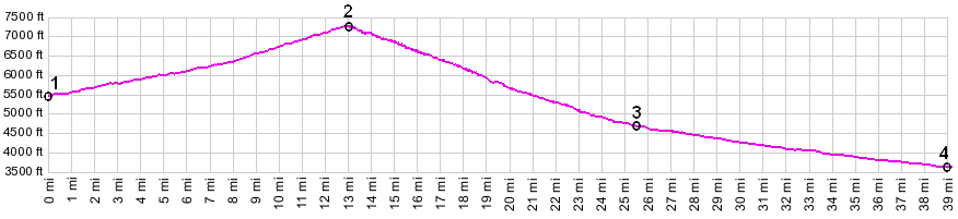
ahead". This is a shameless exaggeration. The road
goes uphill, but as the profile shows, steep is
really something else. A 1:250 000 map shows many
turns in the road west of the summit, and they do
slow down motorists considerably, but switchbacks
are something else again entirely. Also the
surface is fairly smooth medalled with a minimum
of washboard surface (as of Sept/10, but conditons
change). Instead this is a fairly tame, lovely
mountain road, that seems to take no end. There
are no far views to speak of on the ride, but a
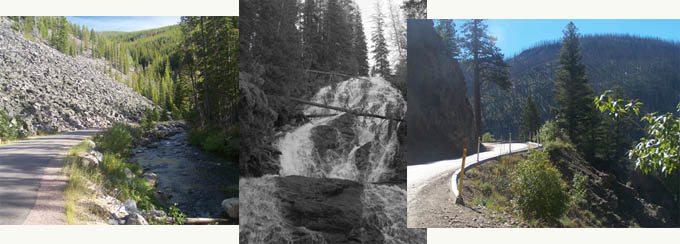
splendid waterfall, no traffic, more trees than
you can ever imagine, and lots of peace.
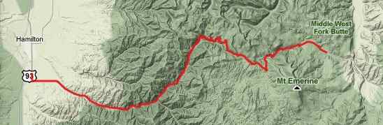
Approaches From East. The road starts climbing
perceptibly after its junction with FR200. It
turns from paved to a smooth dirt surface soon
afterwards. But pavement returns, as the road
takes up the narrow space between West Fork Rock
Creek and a huge talus slope, that crowds the road
onto the very edge of the stream for a while. A
few miles below the summit the road leaves the
creek and now becomes a climb in deep forest. The
shallow wide summit comes up without any prior
notice. There are no views.
From West. (also described upwards)
Turing west onto paved MT38, 2 miles south of
Hamilton, The Skalkaho Road leads in a straight
line towards low wooded mountains, past well to to
do suburban housing and ranches. Somewhere around
mile 14 the road takes on a different character.
The shoulder disappears and a narrow strip of
asphalt closely follows Skalkaho Creek
upwards. Soon the road traverses uphill
along the ridge leaving the creek below. The
opposite ridge has been completely exfoliated by a
forest fire, turning that side into a complete
matchstick forest (Sept/10). The perceived major
attraction on this side, Skalkaho Falls, is signed
6 miles before you get there, and these 6 miles,
go by a lot slower than the previous stretch, due
to somewhat steeper climbing on hard dirt.
The falls are directly next to the road. Motorists
don't even have to get out of the car. After the
drop the stream continues on its way
unceremoniously through a drainage tube under the
road. From this point along the road, one can also
see the short shelf section of the road a few
hundred feet higher. That is about as exciting as
it gets, but who needs excitement when you can
have peace and quiet instead. A few more turns and
the road reaches the summit. Dayride An out and back ride from near the jct Mt38 - FR200 <> Skalkaho Pass <> Hamilton <> starting point, crossing the pass twice measured 88 miles with 5600ft of climbing in 7 hours (VDO MC1.0 m3:10.9.2)
back to Montana's passes and summits by bicycle |