| |
| |
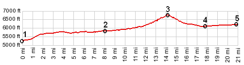
Pine Creek Pass
Pine Creek Pass is a low forested
pass between the Big Hole Mountains to the north
and the Snake River Range to the south. It carries
traffic between points west, onwards over Teton
Pass to Yellowstone and Teton National Parks. It
has little or no shoulder, and traffic can be
moderately heavy during morning and late
afternoon, or other peak traffic periods for the
national parks.
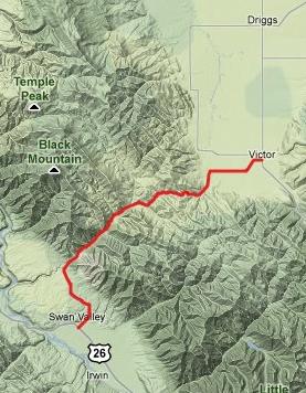
From West. Swan Valley has a gas station
with prices (of not only gasoline) already
influenced by the proximity of national parks. It
seems like every self respecting Yellowstone
tourist has to stop there. Other attractions are
two hamburger or steak restaurants. The road
starts to climb fairly steeply up the rolling
range land at the foot of the Snake River Range.
It crosses Pine Creek before entering the
mountains and promptly levels out into a wide,
partly forested valley. Not until a few miles
before the summit does the grade pick up again
significantly, accompanied by a few wide curves
across from Piney Mountain in the Big Holes. There
are no views from the summit, but a name and
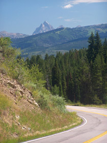
elevation sign. From East. (described downwards). It's a
short coast down into Teton Basin. Along the way
are two quickly passing glimpses of the Teton
peaks. But once you reach the valley you can see
them better from just about everywhere. Dayrides with this point as the highest
summit: COMPLETELY PAVED
An out and back ride starting at jct Fleming
Canyon - Id34 on lower Pine Creek Pass <>
top of Pine Creek Pass <> out and back on
FR253 to Rainey Creek trailhead <> down west
side of Pine Creek Pass <> to a turn around
point at the end of FR543 on Henderson Dry Road on
the eastern end of the Big Hole Mtns: 46 miles
with 3500ft of climbing in 4:0 hours (m3:10.8.4).
|
 Approaches
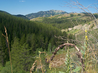
|
|
advertisement |
|
|
advertisement |