| |
| |
Id36 summit(u): Williams
Canyon
The northern end of the Wasatch
Range has little of what comes to mind when you
think of the Wasatch Range in Utah. There are no
escarpments thousands of feet high, no sharp fault
lines that run across the landscape like a ruler.
Here at its northern end the range becomes a
series of rounded, forested hills. Id36 leads
across them in an undramatic fashion that is good
for a nice long meditative bike ride, without
disturbing the thinking process a whole lot. The
route could be used as an alternative to Logan
Canyon, connecting Cache Valley with Bear Lake, if
traffic on a busy summer weekend is a concern. As
for scenery, Beak Lake
Summit is more dramatic.
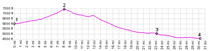
From East. From Orid to Liberty the
road barely climbs at all. Neither town has an
easy way to obtain food or water. The profile
starts in Liberty. The road rolls over a few bare
hills before becoming immersed in dense pine
forest. There are no far views, and Bear Lake
would be too far to the south to be visible. Just
about the only landmark along the way is a sign at
the top with the elevation: 7424ft From West. (described downwards) The
rounded forest hills continue. The road passes a
national forest campground and about 700ft
below the summit. There are also undeveloped
camping opportunities next to the paved road. An
interesting old home before the town of Mink Creek
gives the appearance of being a museum with a few
old, historic buildings apparently transported to
the property. I couldn't tell if this was indeed a
private home. The town of Mink Creek and its
backyards filled with old trucks, motorcycles and
other assorted combustion engine parts lies
slightly off to the south of the highway. Picture locations: left: approaching Mink
Creek, middle: Mink Creek, slight detour from
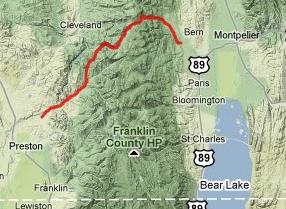
direct route. right: west of summit Tours Dayrides. PARTIALLY PAVED - UNPAVEDNear lower end of Beaver Creek Road, located near town of Mink Creek > up FR407 Beaver Creek Road > up FR408 German Dugway > FR408-421 summit(u) > down Green Basin Road > Paris > Ovid > Id36 summit(u): Williams Canyon > Mink Creek > back to starting point: 56 miles with 4600ft of climbing in 4:55 hours (m3:10.7.31).
|
 Approaches
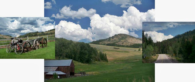
|
|
advertisement |
|
|
advertisement |