Puerto de Santillana s(u) In retrospect, this day was the
best day of this tour. Often the best days are
surprises and this was a complete surprise,
because I really had no idea what to expect. But
even had I known what views, what weather
(-excellent) and what type of scenery
was waiting for me along this ride, I
would still have to rate it ahead of most other
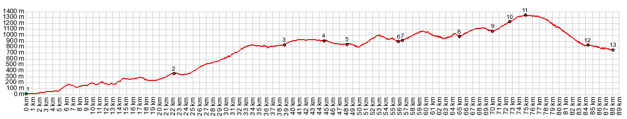
surprises on this tour. There are arguably two paved road passes over the Sierra Nevada, first the 2042 meter high Puerto de la Ragua, and arguably this one. Arguably - because it really just skirts across the eastern end of the range. But it definitely feels like a high crossing on a bike. The landscape here is the special, extremely dry kind. This end of the mountains provide a downslope rainshadow for the moist weather systems, that arrive from the Atlantic. Further down towards Almeria, this results in the driest climate in all of Europe, and that even though it is a coastal area. And then there are the towns along the way. More below.
The profile detours from the new wide highway,
that the main route now follows through the valley
towns Laujar de Andarax and Fondon. Andarax has a
tourist office, which was closed when I was there,
just like they are 90 percent of the time I pass
by them. In the next section the new highway
climbs in mild curves up a rolling dry plain. At
the edge of the shallow valley the remnants of an
older road, with countless scenic turns, going
over old stone bridges is allowed to decay into
nonexistence at its own natural rate. It is a
remainder of a not so distant, quieter, curvier
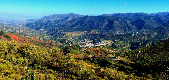
past. Even though my pictures no longer exist, I remember where I took the first photograph, where my jaw dropped. It was from a bridge before reaching the turnoff to Beres. Below lies a vast sweeping view all the way to Almeria and the ocean. Between here and there: rolling waves of dessert badlands and hazy outlines.
These views get even better after the turnoff on
a smaller road to Beres. The route now contours
upwards along the eastern edge of the Sierra
Nevada in open dessert country with unobstructed
views. First Beres - and onward to the figurative
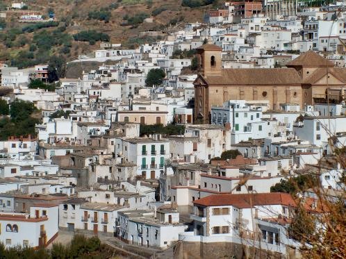
high point, the Alpujarra town Ohanes. It appears like a pattern of white rectangles,
plastered to an otherwise shapeless outrunner of
the Sierra Nevada. The first picture I take has a
large patch of what I would call yucca cacti (but
may well be a different species) in the
foreground, and of course the vllage behind it.
Going into town and entering a bar, I am put in
contact with the owner of a hostal, and so I can
enjoy an evening wandering around the white
streets. There is an especially interesting view
point at sunset at the western exit of this
village, where I take countless pictures with what
I remember as perfect lighting. From the windows
in my room I have more cubist choices of
foregrounds, various walls, flat roofs, wires with
satellite dishes and a whole host of
unidentifiable roof installations. Behind and
above is the giant breadloaf of the Sierra Gador.
No paved road reaches its top.
In Ohanes another more direct road form Almeria
comes up to meet the profiled route. So you could
also make this village a shoulder summit. The ride continues the next morning. The mirador
de Ohanes provides an excuse for drivers to look
at the amazing dry vista towards Almeria again.
Actually, similar views have accompanied the
entire length of the road since before Ohanes.
Below, positioned on various strategically
important hills, or in dales and crevasses lie
parts of more white villages: Almocita, Padues,
Canjayar. Slowly the road continues into a high rolling
plateau scenery, the very eastern end of the
Sierra Nevada. An attractive church appears
between collados. But where is the clientele - or
I mean the town where the congregation lives.
Historically they came from both sides of the
pass. This is the Ermita (Hermitage) de Tices. I seem to remember the summit being at a slightly different spot than the pass, in the short forested section over the top. However the elevation profile puts them extremely close.
SLIDE SHOW1: southern approach as far as Ohanes
From North. (described
downwards). This side goes by rather quickly. A
few switchbacks descend to Abla and the high
valley of the Rio Nacimiento. The village drapes
over a hilltop across from the last part of the
descend. I also take some extreme telephoto shots
of more mysterious churches further up in the
Sierra Nevada. But my favorite vantage point here
is from the bridge across the huge dry arroyo,
before climbing back up into town. Unfortunately
Panoramio has no pictures take from that vantage
point. Between Abla and the next town up valley,
Finana, a forest of windmills is proof that we are
in the 20th century, and these windmills the only
thing resembling a forest in sight. The profile
continues down the valley for a short distance on
the very bikable old road, roughly paralelling the
new 4 lane highway. A Day on a Tour with this point as highes
summit: ( < Haza
del Lino - Albondon s(u) | Calar Alto s(u)
> ) SLIDE SHOW2: from Ohanes over the summit to Abla
|