Mc Cord Pass
This is probably one of the least
known 10000ft unpaved pass roads in Colorado. It
is listed in Helmuth's "Passes of Colorado" book,
which sources it back to quad topo maps. It is not
marked in my (older) National Forest maps. Mc Cord
Pass is located on Piney Ridge, the next range
west of the Gore Range. In between lies the Piney
Valley running straight all the way to Vail. Yet
no real bikable trail runs along the length of the
valley, and the maps in this area seem to be made
to Mexican standards (no insult intended).
For me this is also a pass of two stories. One
side is a steep and rocky climb, yet most of it is
perfectly rideable and with many scenic high
points. The other side is a "where the heck am I"
story. I was glad to have a gps unit along. Even
with maps corresponding to reality, this area has
some confusing twists and turns.
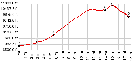 |
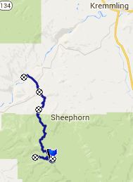
1.(mile00.0,6920ft)
START-NORTH: Radium, bridge over Colorado
River
2.(mile02.9,7260ft)START-END NORTH ALT:
jct: Trough Rd - Sheephorn Rd
3.(mile05.6,7970ft)route turns off
Cottonwood Creek Rd and becomes rougher
4.(mile13.9,10380ft)route passes below
Walter's Lake
5.(mile15.0,10825ft)TOP: McCord Pass
6.(mile17.6,9750ft)START-END SOUTH: end of
road in Box Canyon
|
 Approaches Approaches
From North. The profile
starts in the campsite, called Radium on the map.
The second point is where this river access road
crosses Trough Road (running from State Bridge to
Kremmling). On the east side of Trough Road, the
rout is named Sheephorn Creek Rd. Soon the profile
takes a right onto Cottonwood Creek Road. The fast
and easy dirt road riding soon seems to end. A
sign at a gate prohibits just about everything on
the other side of the gate. When you are close
enough to read the fine print below the signs, you
notice that the public forest road keeps going
after a switchback. It is just much rougher now
that the ranch entrance is now longer subsidized.
Yet it's pleasant enough riding. There are no
rocks here and the deep ruts keep most motor
vehicles away. The road switches back and forth on
sunny rangeland with Trough Road Pass
and the Colorado River appearing in view below. Mc
Cord pass is on the left side of the rocky cliff
ahead, Cottonwood Peak.
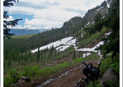
Now the road enters forest and the
first puddles appear. At the next jct the profile
heads uphill on FR401. Now the road makes a long
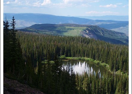
detour to the west in order to attack the rocky
lip from its side. At one point, before the road
starts to deteriorate drastically, the best view
of the entire ride opens up: Piney Valley and the
peaks of the Gore Range, looking along the ridge.
The next right onto FR442 becomes much rockier
with more frequent water puddles covering the
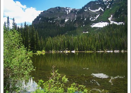
entire road. Finally I reach Walters Lake. On the
other side a small section of shelf road is
visible, still completely covered by an ice sheet.
The remoteness of this scene makes it appear
bigger and more fantastic than it really is. From
here to the ice sheet is extremely rocky so that
riding really takes longer than walking, with all
the getting on and off the bike. That's all right.
I like to walk. The ice sheet is not a big
problem. It is not steep enough to present a
danger and the snow has the right consistency at
the end of June. Instead mosquitoes are the real
problem. This shelf road quickly reaches the top
of the ridge. The view is mostly obscured by
trees. There are better vantage points on the
traverse below.
From South. (described
downwards). My map shows a road heading down the
southern flank of Piney Peak. In reality it has
been closed or abandoned a long time ago. As
evidence there are many logs across the grown over
path. But according to my map this path ends
anyway, and heading south along the ridge does
seem to be more promising.
However my plan was to make this a two way
summit, and for this I headed down the next left
on what is marked FR404 on my forest map. The top
is extremely rocky, but what else is new ? After
descending about 500ft the track became quite
ridable. But then - the track reaches a big meadow
at about 1000ft below the pass. It is not quite as
simple as a track simply ending, because a meadow
of this size can have any number of exit points on
the other side. Isn't this a problem tailormade
for my Garmin gps and its trusty topo maps.
According to it I was right on the road. But
around me was a creek, a swamp, and a little later
wild primeval forest with too many logs to carry a
bicycle across. I followed the imaginary road for
a quarter mile, carrying my bicycle, until reality
caught up with me. There is no road here - even if
a gpsfiledepot map, the de Lorme Gazeteer, and my
forest map from the eighties insist that there is
a road here. Point 6 is where it ends. A name like
Box Canyon is never a good omen. I would be
interest to know, if anybody ever managed to
descend back to Co131 between Walcott and State
Bridge, and which route would be useful for this.
For me it was a long slog back up to the pass.
Dayride with this point as hgihest summit:
PARTIALLY HARD MEDALLED / PARTIALLY UNPAVED
( < FR700
Red Sandstone Road s(u) | FR212
Radium - Tonopas(sh) > )
Mc Cord Pass x2 : Trough Road, a short
distance east of Racho Rio <> Trough Rd east
> up FR401 Sheephorn Rd <> up FR402
Cottonwood Rd <> FR401 north <> FR442
east <> Walters Lake <> Mc Cord Pass
<> down FR404 Box Canyon Rd to end of road
at meadow and firewood area: 37.5miles with 6040ft
of climbing in 6:27hrs (Garmin etrex30 15.6.25).
|