| |
| |
FR500 Red Dirt Park - Hog
Park Reservoir
North of the Mount Circle area, the Continental Divide Trail is deemed unwild enough, so that bicyclists are also permitted to visit the area along the Continental Divide Trail with their favorite mode of transportation. So - what the heck - even if it is just a ride through the forest, and a rocky one at that - it is a Continental Divide Crossing - I thought - and those are special. As it turned out, I was right, but only indirectly. The fact that this road crosses the Continental Divide Trail was the reason, that this turned out to be an interesting ride.
Red Dirt Park is in the Park Range, and turning
off from FR550 onto FR500 it finally dawns on
where this name comes from. I first thought "North
Park" had something to do with why the Park Range
is called Park Range. But cycling around this
exquisite natural lawn the size of crater,
anchored on one side by the rounded off triangle
of Hahn's Peak, it dawns on me. Never mind North
Park. Look at all these parks. This range itself
has the parks. The fact that it is also located
next to the very large North Park is secondary. A few campers are scattered at strategic edges of Big Red Dirt Park, and even these haphazard vehicles appear to add to the scenic punctuation of this place. As FS500 turns left to leave this great park of little parks behind, it quickly deteriorates into a steep climb, with many ruts but very few rocks. It winds its way up into a maze of what used to be evergreen covered hills, and are now a skeleton of branches left over by the pine beetle. Surprisingly there are even a few decent views, where you can peek between the branches on make out the Elkhead Range and Hahn's Peak.
The weather deteriorates again and I wonder if
another wet ride through endless forest is really
worth all that getting wet. Meanwhile the trail
seems to crest between puddles on a broad ridge. I
look for a Continental Divide Crossing Trail sign,
but don't see any. The only people I saw since Red
Dirt Park were two motorcyclists. And then there was also a girl sitting under a
tree holding an umbrella. So actually FR500 had
been following the Continental Divide Trail since
somewhere near that park of little parks, Shera
told me, and she had to know, because she had been
walking on it. Actually she had been on the CD
trail since Mexico... "and this umbrella is the
best thing I brought" she told me, sheltering
under a tree from the rain, that was about to
break loose in earnest. Mary Poppins with her
umbrellas, flying over the rooftops with her
umbrellas would not have surprised me more, and
did not look half as enchanting. We walked a short distance together, owing to the
fact that I was somewhat lost due to my outdated
maps. Her phone apps on the other hand were
completely up to date. "This is the first time I
am hiking with technology" she told me. I write
with it . I communicate with it . I take pictures
with it and I navigate with it." As it turned out
this was a hike with the most hikingest person I
will probably ever know. She had walked the
Pacific Crest Trail, the Appalachian Trail,
Colorado Trail, Arizona Trail, and I forgot the
rest, all in their entirety - by herself. This was
the last and hardest of the American long distance
trails, she told me. Her memories of climbing over
Gray's Peak and skiing a distance at Cumbres Pass
were still fresh, and it showed in her face. Her
next time away from the trail is an outdoor
equipment fair, where she will work for her
sponsors. And of course she has a blog and even is
a professional writer (among other things) Sherahikes.wordpress.com.
- The road summits in forest without views, in
between stories, after a short steep rocky
section. (descirbed downwards) The extremely rocky part of
FR500 finally comes to an abrupt end after it
descends to a junction with a closed road. Here
the CD Trail TR1101 also deviates to the left. The
intersection is well signed. The abandoned road
now becomes a fast biking route. The date of
abandonment seems to be fairly recent (as of July
2015). There are a few trees across the road, but
the surface is perfect. A single rocky outcrop,
somewhere to the east is just barely a good enough
as landmark, to confirm the fact that the road
twists and turns over hundreds of degrees, but
generally heads north. The last descend leads into
Hog Park - yet another oval shaped lawn, heaven
for sheep and cows, great for people too, ringed
by scrubby forest that recedes into endless waves
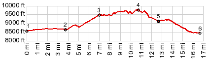
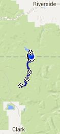
of hills. 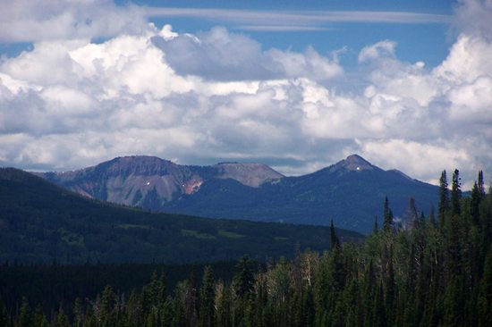 Dayride with this point as highest summit: PARTIALLY PAVED / UNPAVED (< FR700
Chimney Rock Rd s(u) | CR62
Steamboat Lake(sh) >) 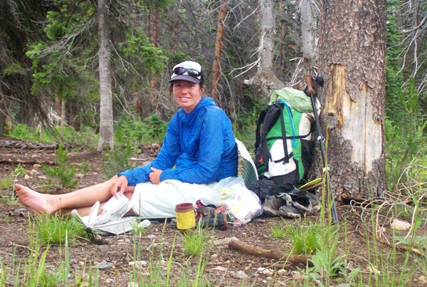 not just another Continental Divide traveler |


|
|
advertisement |
|
|
advertisement |