| |
| |
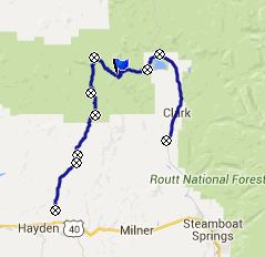
FR42 Mill Creek Rd s(u)
This double track trail is part
of the Great Divide mountain bike touring route.
It's the northernmost summit in Colorado on that
route. It crosses between the sparsely populated
park scenery of Colorado's north western plateaus
and the Hahn Creek Basin, which even has a paved
road, along with stores, bars and the like.
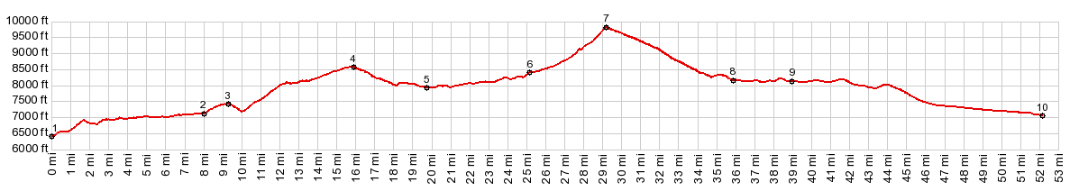
After crossing point 4, the FR150
Hayden - California Park summit, the road
reaches a low point in California Park at point 5.
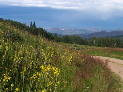
This is a fascinating simplistically geometric
landscape. Mountains are shaped like blocks or
triangles, and the grassy plains sweep up to their
feet. Within this big block landscape the forest
service has erected small wooden signs, that stand
out like the talking bubbles in a cartoon. They
label creeks, mountains and parks, like Meaden
Peak (10561ft) for example. FR42 will summit just
to the north of it. But these signs also help not
getting lost - at least if you carry along a
National Forest map, which labels the streams. The
road here is graveled, but has no washboard
surface. From California Park the road climbs an umarked
summit, here called the FR150
California Park Savery summit. At the top
stands a "Slater Park" sign, and a second sign
pointing the way to "Hahn's Creek Basin", which
infuses a little more confidence about reaching
the destination from this remote area for first
time visitors. FR42 is a smaller road, with a surface better for
mountain biking, and has a seasonal closure for
motor vehicles. At one point this road with a very
civilized appearance, fit for a park of the man
made kind, changes abruptly into a jeep trail,
that climbs very steeply in the forest. Not until
500ft before approaching the summit, does the road
break out into two meadows (more parks - this time
the kind made exclusively by nature). All the
geometrical landmarks appear again, but this time
from a different vantage point. You can see as the
gap near the summit approaches, but the actual
summit comes up unexpectedly in the forest. There
is a fork at the summit. My gps showed me to stay
right here, so I did not explore the other option.
The road remains really rocky to about 8300ft
elevation..Here a sign announces logging traffic.
This was great, I thought, and I was right. There
were no logging trucks, but as expected, the road
became perfect for a fast descent into the
uppermost houses around Steamboat Lake. From here the profile contours along the north
end of the lake. The nicest views are from this
side of the lake. Then the profile merges onto the
paved road down down direction Steamboat Springs. The Great Divide Route on the other hand stays on
the unpaved CR62, on the west side of the valley.
Personally I think the paved road is actually more
scenic. There is a profile of both sides on the CR62
Steamboat Lake(sh) page.
Dayride with this point as highest summit PARTIALLY PAVED / UNPAVED ( < CR62
Steamboat Lake(sh) | FR411
Hahn's Peak(sh) > ) ( < FR411
Hahn's Peak(sh) | Wy70 Battle
Lake Pass Rd(sh) > ) |
|
|
advertisement |
|
|
advertisement |