< Left Panel   Colorado Summits and Passes   Areas   Tables   Maps   All Favorites  
Main Panel:   Main Page   Map+Profile   Colorado Map  


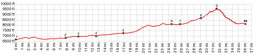
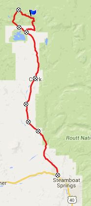
FR411 Hahn's Peak(sh)

There are many rough and rocky trails on all sides of Hahn's Peak, that are frequented by motor people and mountain bikers. This is one of the most obvious routes. But there are many higher ones.

01.(mile00.0,6680ft) START-END: START-END SOUTH: jct Elk River Rd - US40, just west of Steamboat Springs
02.(mile07.8,6820ft) jct with CR52e on left
03.(mile09.8,6950ft) jct with CR54 on left
04.(mile10.8,6970ft) jct with CR56 on left
05.(mile16.9,7270ft) jct with CR62 and Great Divide bike to Steamboat Lake on left
06.(mile24.5,8140ft) jct with FR13 in town Hahn's Peak same as point 10
07.(mile25.8,8120ft) jct with CR62 and closest entrance to Steamboat Lake
08.(mile29.1,8680ft) profile turns right onto FR1 at top of Columbine Pass
09.(mile31.5,9560ft) TOP: FR411 Hahn's Peak s(u)
10.(mile36.0,8149ft) START-END NORTH: town Hahn's Peak, jct with FR13; same as point 6

Approaches

From North.
At the top of Columbine Pass, a good dirt road takes off straight direction east and Hahn's Peak. It passes a few houses in the woods. Then the profile turns off left onto FR490.

After a short, fairly steep climb, FR490 turns right, while staying straight leads to a parking lot for TR1158 and FR418. These two route designations split further up. Both TR and FR lead to this shoulder summit, located at treeline of a shoulder on Hahn's Peak. Bikes are allowed on both routes.

But this profile does not go to that shoulder summit point. Instead it elects to stay lower and takes the turnoff onto FR490. Every couple of hundred pedal strokes you are confronted with the same decision anew, keep left and keep climbing, turn off right and descend direction Hahn's Peak Basin. The place where I decided to turn down happened to be on FR411.

From South. The top stretch is too rocky to ride down. But after a while the route levels out on a low ridge above Steamboat Lake, before descending the rest.

Dayride with this point as highest point:

PARTIALLY PAVED / UNPAVED / SINGLE TRACK

( < FR42 Mill Creek Rd s(u) | FR42 Mill Creek Rd s(u) > )
FR411 Hahn's Peak(sh) , FR488 - TR1156 s(u) Hahn's Peak Lake area , additonal out and back: FR488 near jct with Columbine Pass > jct FR488 - TR1156 Hahn's Peak Lake area <> out and back to end of FR488 >> TR1156 west > FR487 east > CR129 north > Columbine Pass(shp) > FR490 east <> out and back to TR1158/FR418 TH >> up FR490 > FR411 Hahn's Peak(sh) > Hahn's Peak Basin > CR129 north back to starting point: 27.4miles with 3240ft of cllimbing in 4:10hrs (Garmin etrex30, m5:15.6.13).
Notes: This was really two separate trips in one. The first part was an aborted try to get over the ridge to Savery Park on TR1156. The best part of the day was a hike to the top of Hahn's Peak from the trailhead.


advertisement

advertisement