| |
| |
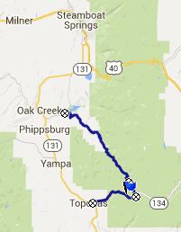
Co134 near Toponas (via Lynx
Pass)
 Sometimes
passes and water divides don't like to follow the
numerical rules, that mathematically impaired
people like myself like to make up, regarding what
makes a summit. One of these rules that I set up
for these pages is, that each approach has to be
at least 500ft high. Sometimes
passes and water divides don't like to follow the
numerical rules, that mathematically impaired
people like myself like to make up, regarding what
makes a summit. One of these rules that I set up
for these pages is, that each approach has to be
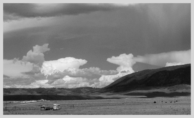
at least 500ft high.Take Lynx Pass for example, a popular MTB bicycle touring route. There are more bike tracks here than on any other dirt road in the Gore Range, higher or lower; the reason - it's on the Great Divide bike route. Make a route to ride and people will ride it and even race it. I saw dozens of them. On the south side of Lynx Pass, the dirt road it meets paved Co134 about 320 ft below the Lynx Pass summit. Co134 heads for points higher than Lynx Pass in both directions, even if in one case it is only 20ft higher. Also none of the dirt roads on either side of Co134 head any lower. So this page is about the higher point on Co134. But going down Lynx Pass on one side is a necessary condition to make the Co134 point a summit.
Approaches
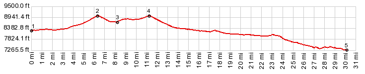
From North. (described
downwards) After descending a little over 300ft
the road reaches a low point approaching Decker
Creek. A dirt road crosses here. All roads lead to
higher elevations except one, and that is the dirt
road on the left over Lynx Pass. The profile turns
left and follows the road past a fishing pond and
a forest service facility to a well defined top.
There is a trailhead here for the Morrison Divide
Trail to the west of the pass. Past this shoulder point, rolling down, the dirt
road crossed from national forest onto private
land relatively quickly. Here begins an entire
apparently unnamed town of widely spaced
settlements, connected by roads with names such as
Filly Lane and Colt Lane. I want to call it a
suburb of Steamboat Springs, but that is many
miles to the north. It is also where these people
have to drive to buy their milk. So you better
bring back a tanker of milk to make it worthwhile. This collection of settlements lasts all the way
to a lake in the sagbrush landscape, Stagecoach
Reservoir, again surrounded by a real estate
agent's dream come true. PARTIALLY PAVED / UNPAVED same summit point: jct Co134 - FR270 to
Lynx Pass > Lynx Pass > CR14 north >
Yellowjacket Pass(shp) > Co134 south > Yampa
> Tonapas > Co134 east > Co134 Tonopas
s(u) > back to starting point: jct Co134 -
FR270 to Lynx Pass (mechanical odometer: 88.9.25) |
|
|
advertisement |
|
|
advertisement |