| |
|
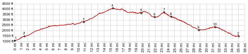
01.(1090ft,mile00.0)START-END SOUTH-1: FR25 crosses the Cispus River
02.(1570ft,mile01.6)jct FR25 - FR26
03.(2920ft,mile10.9)profile turns left onto FR99
04.(4110ft,mile15.2)TOP:turnoff to Bear Meadow view point
05.(3640ft,mile19.9)profile turns right onto FR26 to Norwegian Pass
06.(3280ft,mile22.0)intermediate low point
07.(3710ft,mile23.4)intermediate high point
08.(3330ft,mile24.7)jct with FR2612 and Ryan Lake on left
09.(2090ft,mile28.9)intermediate low point
10.(2440ft,mile31.4)intermediate summit
11.(1570ft,mile35.1)START-END SOUTH-2 FR26 terminates on FR25, same as point 2
|
|
-