| |
|
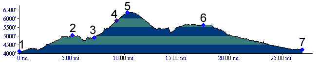
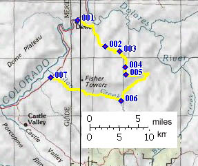
01.(4140ft,mile00) START-END EAST: Dewey Bridge
02.(5040ft,mile05) Kokopelli Trail and "End of the world Road" turn off on right, followed by another immediate left branch of the profile route
03.(4930ft,mile07) turn right onto gravel road
04.(5900ft,mile10) Kokopelli Trail stays left
05.(6370ft,mile11) TOP
06.(5630ft.mile18) profile turns right, down into Fisher Valley, while Kokopelli Trail stays left.
07.(4220ft,mile27) START-END WEST: junction of Onion Creek rd with paved road.