|
-
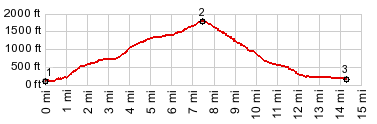
1.(100ft,mile00.0)START-END EAST: Mosier, low point near Columbia River
2.(1800ft,mile07.5)TOP: highest point on Seven Mile Hill Rd
3.(1700ft,mile14.2)START-END WEST: the Dalles: jct W10th St - Webber St
View Or_seven_mile_hill_rd_u.gpx in a larger map |
-