| |
|
|
|
-
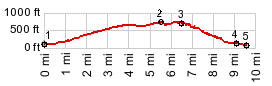
1.(100ft,mile00.0)START-END
EAST: Mosier, low point near Columbia River
2.(740ft,mile05.5)TOP: highest point
3.(680ft,mile06.7)turoff on right to Rowena Crest
viewpoint
4.(140ft,mile09.1)START-END WEST: jct US30 - I84
5.(80ft,mile09.8)START-END WEST ALTERNATE: low point
in a State Park on Columbia River Rd
|
|
-