|
-
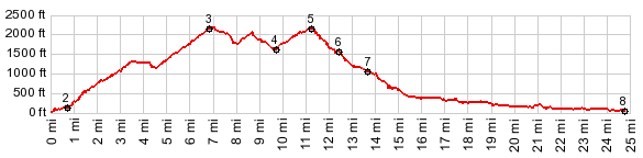
1.(20ft,mile00.0)START-END NORTH: low point on US101
2.(140ft,mile00.7) profile turns right onto Fairview Mtn Rd
3.(2230ft,mile06.8)intermediate top: Fairview Mtn Rd s(u)-2
4.(1670ft,mile09.8)intermediate low point
5.(2240ft,mile11.2)TOP
6.(1600ft,mile12.4)profile turns right onto FR58
7.(1130ft,mile13.7)profile turns left onto Big Creek Rd
8.(130ft,mile24.6)START-END SOUTH: North Fork Rd reaches Siuslaw River
View Or_fairview_mtn in a larger map |
-