| |
|
|
|
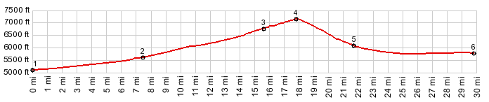
1.(5100ft,mile00.0) START-END EAST: jct Ut159 - US50, just east of Ut-Nv line
2.(5600ft,mile07.5) jct with Nv487 on left to Baker
3.(6814ft,mile15.6) dirt road on left is CR38, Osceola Rd
4.(7136ft,mile17.9) TOP: point of highest elevation
5.(6080ft,mile21.7) jct with CR37 on right
6.(5780ft,mile29.9) START-END WEST: jct with CR38, Osceola Rd on left
|
|