| |
|
|
|
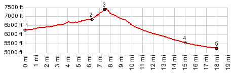
1.(6240ft,mile00.0)ranch access road heads west, following Old Overland Road
2.(6920ft,mile06.3) profile goes right
3.(7440ft,mile07.6) TOP, profile stays right, immediately after summit
4.(5540ft,mile15.1)first of several forks, all of which go to US50; profile stays left here
5.(5250ft.mile18.0) jct US50 - Overland Rd
|
![]()