| |
|
|
|
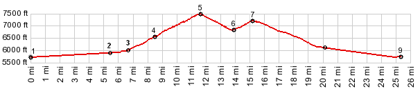
1.(5730ft,mile00.0)START-END WEST ALT: jct US50 - Old Overland Road
2.(5880ft,mile05.5)jct US50 - Nv722, west of Austin
3.(6030ft,mile06.7)jct with Big Creek Rd on left, access to Toiyabe Range summits
4.(6590ft,mile08.6)START-END WEST: center of Austin
5.(7484ft,mile11.5)TOP: Austin Summit and jct with roads to Emigrant Pass and Austin Crest Trail
6.(6840ft,mile14.0)Grass Valley Rd takes off on left
7.(7267ft,mile15.2)Bob Scott Summit
8.(6070ft,mile20.2)START-END EAST ALT: jct with Nv376 on left
9.(5740ft,mile25.2)START-END EAST: slight curve in US50, marking southernmost point in valley
|