|
|
|
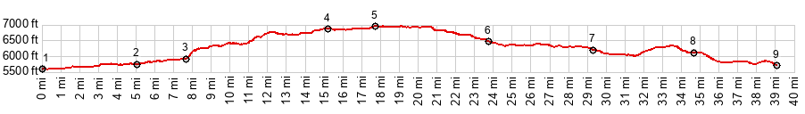
1.START-END SOUTH:Five Mile Bridge, close to CR4450
2.route turns left up Jesus Canyon
3.route goes right on steep uphill
4.profile joins CR520
5.TOP, 6980ft
6.profile turns right onto paved US64
7.profile turns right onto NM539
8.Navajo Dam
9.START-END NORTH:relative low point between Navajo Dam and Archuleta
|
--endhere--