| |
|
|
|
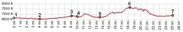
1.(00.0km~00.0mi, 2018m~6620ft)
START-END EAST: jct Mt87 - US20 east of Henry's Lake
2.(04.1km~02.5mi, 1980m~6496ft) low point
3.(14.8km~09.2mi, 2080m~6824ft) Raynold's Pass
4.(16.1km~10.0mi, 2068m~6785ft) route turns left onto
FR230
5.(22.1km~13.7mi, 2043m~6703ft) intermediate low point
at turnoff to private road on r6ght
6.(29.3km~18.3mi, 2323m~7650ft) TOP: Lone Tree Pass;
profile between here and western starting point is
approximate and differs in details from the
description
7.(40.5km~25.2mi, 2087m~6847ft) START-END WEST: jct
with South Valley Rd to Red Rock Pass
| |