| |
|
|
|
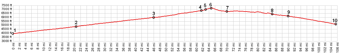
01.(000.0km~000.0mi, 1203m~3947ft)
START-END NORTH ALTERNATE: Salmon River Crossing in
Salmon
02.(033.1km~020.6mi, 1475m~4839ft) Tendoy and jct with
Lewis and Clarke Road to Lemhi Pass
03.(074.1km~046.0mi, 1819m~5968ft) START-END NORTH:
Leadore and jct with road to Bannock Pass
04.(098.9km~061.5mi, 2079m~6821ft) jct with FR212 on
right to Sheephorn Peak
05.(101.4km~063.0mi, 2123m~6965ft) jct with FR2,
Gilmore Rd to Meadow Lake
06.(104.5km~065.0mi, 2190m~7186ft) TOP: Gilmore Summit
and nearby jct dirt road to Eighteen Mile road on left
07.(110.7km~068.8mi, 2060m~6759ft) jct with FR296
Spring Mtn Rd crossing Lemhi Range on left
08.(136.3km~084.7mi, 1952m~6402ft) START-END SOUTH
ALTERNATE: Birch Creek crosses road from west to east,
near Pine Creek and fishing access area
09.(144.4km~089.7mi, 1878m~6161ft) jct with Pass Creek
Rd on left
10.(170.0km~105.6mi, 1014m~5327ft) START-END SOUTH:
jct Id28 - Id22, north west of Mud Lake
profile is half scale but same vertical exageration (9.1) compared to others in these pages.
|
|