| |
|
|
|
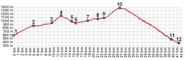
01.(00.0km,596m) START-END SOUTH ALT: D526 bridge across Drac, south of La Mure
02.(04.7km,876m) east end of La Mure
03.(09.5km,953m) Nantes en Ratier
04.(12.0km,m) Col de Malissol
05.(14.5km,1003m) la Valette
06.(15.5km,950m) START-END SOUTH: intermediate low point
07.(18.5km,1012m) Fontagneu
08.(21.1km,1061m) les Mazoirs
09.(22.6km,1096m) lower turnoff to Moulin Viex, near le Villard
10.(26.5km,1379m) TOP: point of highest altitude, just east of town la Morte
11.(39.4km,494m) road on left goes to Laffrey
12.(41.5km,371m) START-END NORTH: road joins D1091 in Gorge de la Romanche
|
|